Whitestaunton
From Wikishire
Revision as of 12:25, 14 May 2018 by RB (Talk | contribs) (Created page with "{{Infobox town |name=Whitestaunton |county=Somerset |picture=Whitestaunton - St Andrews church - geograph.org.uk - 223373.jpg |picture caption=Church of St Andrew, Whitestaunt...")
| Whitestaunton | |
| Somerset | |
|---|---|
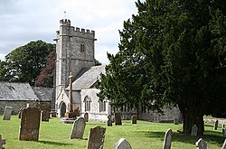
 Church of St Andrew, Whitestaunton | |
| Location | |
| Grid reference: | ST285105 |
| Location: | 50°53’20"N, 3°1’23"W |
| Data | |
| Population: | 256 (2011) |
| Post town: | Chard |
| Postcode: | TA20 |
| Dialling code: | 01460 |
| Local Government | |
| Council: | South Somerset |
| Parliamentary constituency: |
Yeovil |
Whitestaunton is a village in Somerset. The parish includes the hamlet of Northay.
The Church of St Andrew dates from the 13th century and has been designated as a Grade I listed building.[1]
The parish is within the South Petherton Hundred of Somerset.[2]
History
A mile west of the village lies Horse Pool Camp, a univallate Iron Age hill fort. The hill fort is an oval univallate 350 yards long and 180 yards wide.[3][4]
A Roman bath house and Edwardian folly in the village were excavated by the television series Time Team.[5]
Whitestaunton Manor dates from the 15th century and is a Grade I listed building.[6]
Outside links
| ("Wikimedia Commons" has material about Whitestaunton) |
References
- ↑ Images of England — details from listed building database (433246) Church of St Andrew
- ↑ "Somerset Hundreds". GENUKI. http://www.genuki.org.uk/big/eng/SOM/Miscellaneous/. Retrieved 20 October 2011.
- ↑ "Horse Pool Camp". Somerset Historic Environment Record. Somerset County Council. http://www.somersetheritage.org.uk/record/53259. Retrieved 26 August 2011.
- ↑ National Monuments Record: No. 189963 – Whitestaunton Camp
- ↑ "A Roman bath house and Edwardian folly". Time Team microsite. Channel 4. 11 January 2004. http://www.channel4.com/history/microsites/T/timeteam/2004_white.html. Retrieved 2008-02-09.
- ↑ Images of England — details from listed building database (433262) Whitestaunton Manor