Difference between revisions of "Water End, Hampshire"
From Wikishire
(Created page with '{{Infobox town |name=Water End |county=Hampshire |os grid ref=SU691529 |latitude=51.271062 |longitude=-1.009787 |postcode=RG24 |LG district=Basingstoke & Deane }} '''Water End'''…') |
m |
||
| (One intermediate revision by the same user not shown) | |||
| Line 2: | Line 2: | ||
|name=Water End | |name=Water End | ||
|county=Hampshire | |county=Hampshire | ||
| + | |picture=The Red Lion, Water End - geograph.org.uk - 147156.jpg | ||
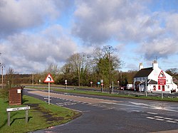
| + | |picture caption=The Red Lion, Water End | ||
|os grid ref=SU691529 | |os grid ref=SU691529 | ||
|latitude=51.271062 | |latitude=51.271062 | ||
| Line 8: | Line 10: | ||
|LG district=Basingstoke & Deane | |LG district=Basingstoke & Deane | ||
}} | }} | ||
| − | '''Water End''' is a hamlet on the [[Lyde River]] and the A30 dual carriageway between [[Old Basing]] (west) and [[Hook, Hampshire|Hook]] (east). Nately Scures]] is just to the east. It has a pub. | + | '''Water End''' is a hamlet on the [[Lyde River]] and the A30 dual carriageway between [[Old Basing]] (west) and [[Hook, Hampshire|Hook]] (east). [[Nately Scures]] is just to the east. It has a pub, The Red Lion. |
{{stub}} | {{stub}} | ||
Latest revision as of 22:11, 22 November 2012
| Water End | |
| Hampshire | |
|---|---|
 The Red Lion, Water End | |
| Location | |
| Grid reference: | SU691529 |
| Location: | 51°16’16"N, 1°-0’35"W |
| Data | |
| Postcode: | RG24 |
| Local Government | |
| Council: | Basingstoke & Deane |
Water End is a hamlet on the Lyde River and the A30 dual carriageway between Old Basing (west) and Hook (east). Nately Scures is just to the east. It has a pub, The Red Lion.
This Hampshire article is a stub: help to improve Wikishire by building it up.