Wakerley
| Wakerley | |
| Northamptonshire | |
|---|---|
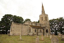
 St John the Baptist, Wakerley | |
| Location | |
| Grid reference: | SP952995 |
| Location: | 52°35’6"N, 0°35’31"W |
| Data | |
| Population: | 60 (approx.) |
| Post town: | Oakham |
| Postcode: | LE15 |
| Dialling code: | 01572 |
| Local Government | |
| Council: | North Northamptonshire |
| Parliamentary constituency: |
Corby |
Wakerley is a linear village in northern Northamptonshire. It is on the south bank of the River Welland (which forms the border with Rutland). Its nearest neighbour is Barrowden in the latter county, and accessible by a footbridge across the Welland.
The village is in the area of Rockingham Forest and Wakerley Great Wood is one of the forest's largest remnants. The population of the village is included in the civil parish of Duddington with Fineshade.
The village's name origin is dubious. 'Osier meadow' or perhaps, 'watcher clearing' have been suggested.[1]
St John the Baptist's Church, a Grade I listed building, has been in the care of the Churches Conservation Trust since the early 1970s.[2]
Recent evidence points to Wakerley's industrial history as an iron-smelting centre. Brick-built calcining kilns were used for reducing iron ore before transport to the Corby Steelworks.[3]
Outside links
| ("Wikimedia Commons" has material about Wakerley) |
References
- ↑ "Key to English Place-names". http://kepn.nottingham.ac.uk/map/place/Northamptonshire/Wakerley.
- ↑ "Wakerley, Northamptonshire: Church of St John the Baptist". http://www.visitchurches.org.uk/Ourchurches/Completelistofchurches/Church-of-St-John-the-Baptist-Wakerley-Northamptonshire/. Retrieved 8 April 2016.
- ↑ Laundon, Jack Rodney (2008). "The Wakerley Calciner Furnaces". Northamptonshire Past and Present 61: 86-87. http://www.northamptonshirerecordsociety.org.uk/eNpp/NppNo61.pdf.