User:Yaxley/County populations
From Wikishire
< User:Yaxley
Revision as of 03:54, 19 January 2014 by Yaxley (Talk | contribs) (Requires collapsible JavaScript data to be copied over to WS.)
This page details the 2011 populations of all the counties of England, Ireland, Scotland and Wales.
Statistics
| Name | Alternative Name | Area | 2011 Population | Density | |
|---|---|---|---|---|---|
| Aberdeenshire | Obar Dheathain | 1950 | |||
| Anglesey | Sir Fôn | 276 | 69,751 | 253 | |
| Angus | Aonghas | 889 | |||
| Antrim | Aontroim | 1175 | 618,108 | 526 | |
| Argyllshire | Earra-Ghàidheal | 3110 | |||
| Armagh | Ard Mhacha | 512 | 174,792 | 341 | |
| Ayrshire | Inbhear Áir | 1129 | |||
| Banffshire | Banbh | 641 | |||
| Bedfordshire | 465 | 596,702 | 1283 | ||
| Berkshire | 722 | 847,906 | 1174 | ||
| Berwickshire | Bearaig | 457 | |||
| Brecknockshire | Sir Frycheiniog | 743 | 59,447 | 80 | |
| Buckinghamshire | 745 | 774,288 | 1039 | ||
| Buteshire | Bód | 225 | |||
| Caernarfonshire | Sir Gaernarfon | 480 | 113,206 | 236 | |
| Caithness | Gallaibh | 618 | |||
| Cambridgeshire | 820 | 459,551 | 560 | ||
| Cardiganshire | Ceredigion | 815 | 75,922 | 93 | |
| Carlow | Ceatharlach | 346 | 54,612 | 158 | |
| Carmarthenshire | Sir Gaerfyrddin | 1095 | 184,287 | 168 | |
| Cavan | An Cabhán | 746 | 73,183 | 98 | |
| Cheshire | 1027 | 1,690,526 | 1646 | ||
| Clackmannanshire | Clach Mhanainn | 48 | |||
| Clare | An Clár | 1330 | 117,196 | 88 | |
| Cork | Corcaigh | 2895 | 519,032 | 179 | |
| Cornwall | Kernow | 1349 | 533,591 | 396 | |
| Cromartyshire | Cromba | 370 | |||
| Cumberland | 1516 | 306,031 | 202 | ||
| Denbighshire | Sir Ddinbych | 640 | 257,724 | 403 | |
| Derbyshire | 1029 | 1,179,988 | 1147 | ||
| Derry | Doire | 816 | 247,132 | 303 | |
| Devon | 2405 | 1,133,248 | 471 | ||
| Donegal | Dún na nGall | 1869 | 161,137 | 86 | |
| Dorset | 980 | 539,728 | 551 | ||
| Down | An Dún | 950 | 531,665 | 560 | |
| Dublin | Áth Cliath | 356 | 1,273,069 | 3576 | |
| Dumfriesshire | Dún Phrís | 1063 | |||
| Dunbartonshire | Dún Breatainn | 241 | |||
| Durham | 1015 | 1,466,882 | 1445 | ||
| East Lothian | Labhaidh Thoir | 267 | |||
| Essex | 1542 | 3,004,952 | 1949 | ||
| Fermanagh | Fear Manach | 715 | 61,170 | 86 | |
| Fife | Foibhe | 504 | |||
| Flintshire | Sir y Fflint | 640 | 211,157 | 330 | |
| Galway | Gaillimh | 2374 | 250,541 | 106 | |
| Glamorgan | Morgannwg | 845 | 1,324,690 | 1568 | |
| Gloucestershire | 1125 | 1,152,909 | 1025 | ||
| Hampshire | 1622 | 2,104,690 | 1298 | ||
| Herefordshire | 833 | 182,883 | 220 | ||
| Hertfordshire | 727 | 1,118,418 | 1538 | ||
| Huntingdonshire | 359 | 210,392 | 586 | ||
| Inverness-shire | Inbhear Nis | 4211 | |||
| Kent | 1555 | 2,799,496 | 1800 | ||
| Kerry | Ciarraí | 1832 | 145,502 | 79 | |
| Kildare | Cill Dara | 654 | 210,312 | 322 | |
| Kilkenny | Cill Chainnigh | 800 | 95,419 | 119 | |
| Kincardineshire | An Mhaoirne | 380 | |||
| Kinross-shire | Ceann Rois | 73 | |||
| Kirkcudbrightshire | Cille Chuitbeirt | 899 | |||
| Lanarkshire | Lannraig | 879 | |||
| Lancashire | 1880 | 4,929,663 | 2622 | ||
| Laois | Laois | 660 | 80,559 | 122 | |
| Leicestershire | 800 | 973,929 | 1217 | ||
| Leitrim | Liatroim | 613 | 31,796 | 52 | |
| Limerick | Luimneach | 1064 | 191,809 | 180 | |
| Lincolnshire | 2646 | 1,038,763 | 393 | ||
| Longford | An Longfort | 421 | 39,000 | 93 | |
| Louth | Lú | 319 | 122,897 | 385 | |
| Mayo | Maigh Eo | 2157 | 130,638 | 61 | |
| Meath | An Mhí | 904 | 184,135 | 204 | |
| Merioneth | Meirionnydd | 780 | 36,769 | 47 | |
| Middlesex | 285 | 4,040,459 | 14177 | ||
| Midlothian | Labhaidh Láir | 362 | |||
| Monaghan | Muineachán | 500 | 60,483 | 121 | |
| Monmouthshire | Sir Fynwy | 530 | 465,901 | 879 | |
| Montgomeryshire | Sir Drefaldwyn | 780 | 62,172 | 80 | |
| Moray | Móireabh | 476 | |||
| Nairnshire | Inbhear nÁrainn | 200 | |||
| Norfolk | 2044 | 834,956 | 408 | ||
| Northamptonshire | 984 | 709,204 | 721 | ||
| Northumberland | 2018 | 797,006 | 395 | ||
| Nottinghamshire | 825 | 1,092,924 | 1325 | ||
| Offaly | Uíbh Fhailí | 800 | 76,687 | 96 | |
| Orkney | Arcaibh | 376 | |||
| Oxfordshire | 756 | 521,280 | 690 | ||
| Peeblesshire | Na Púballan | 548 | |||
| Pembrokeshire | Sir Benfro | 655 | 121,929 | 186 | |
| Perthshire | Peairt | 3493 | |||
| Radnorshire | Sir Faesyfed | 485 | 25,821 | 53 | |
| Renfrewshire | Rinn Friú | 245 | |||
| Roscommon | Ros Comáin | 983 | 64,065 | 65 | |
| Ross-shire | Ros | 3089 | |||
| Roxburghshire | Rosbróg | 666 | |||
| Rutland | 152 | 37,369 | 246 | ||
| Selkirkshire | Salcraig | 267 | |||
| Shetland | Sealtainn | 225 | |||
| Shropshire | 1343 | 472,770 | 352 | ||
| Sligo | Sligeach | 709 | 65,393 | 92 | |
| Somerset | 1640 | 1,050,003 | 640 | ||
| Staffordshire | 1171 | 2,111,133 | 1803 | ||
| Stirlingshire | Sruighlea | 447 | |||
| Suffolk | 1489 | 745,038 | 500 | ||
| Surrey | 758 | 2,923,221 | 3856 | ||
| Sussex | 1458 | 1,606,882 | 1102 | ||
| Sutherland | Cataibh | 2028 | |||
| Tipperary | Tiobraid Árann | 1661 | 158,754 | 96 | |
| Tyrone | Tír Eoghain | 1260 | 177,986 | 141 | |
| Warwickshire | 885 | 1,756,933 | 1985 | ||
| Waterford | Port Láirge | 717 | 113,795 | 159 | |
| West Lothian | Labhaidh Thiar | 120 | |||
| Westmeath | An Iarmhí | 710 | 86,164 | 121 | |
| Westmorland | 783 | 92,940 | 119 | ||
| Wexford | Loch Garman | 909 | 145,320 | 160 | |
| Wicklow | Cill Mhantáin | 781 | 136,640 | 175 | |
| Wigtownshire | Baile na hUige | 487 | |||
| Wiltshire | 1370 | 681,970 | 498 | ||
| Worcestershire | 738 | 1,055,741 | 1431 | ||
| Yorkshire | 6066 | 5,198,017 | 857 |
Notes
- Statistical information has been taken from the 2011 English and Welsh Census, and the 2011 Irish Census.
- Geographical information has been taken from the Historical Counties Trust.
- Area and density are both measured in square miles.
- For population graphs, population is measured in thousands. For example 211 represents a population of 211,000.
- Alternative names are given in the Cornish, Irish, Scottish and Welsh languages.
Graphs
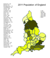
English counties population graph.
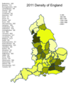
English counties density graph.
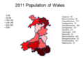
Welsh counties population graph.
Welsh counties population graph.

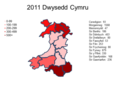
Welsh counties population graph in Welsh.
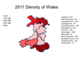
Welsh counties density graph in Welsh.


