Theale, Somerset
From Wikishire
Revision as of 13:46, 7 March 2024 by RB (Talk | contribs) (Created page with "{{Infobox town |name=Theale |county=Somerset |picture=Theale (Somerset). Christ Church.jpg |picture caption=Christ Church, Theale |os grid ref=ST449462 |latitude=51.212943 |lo...")
| Theale | |
| Somerset | |
|---|---|
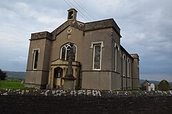
 Christ Church, Theale | |
| Location | |
| Grid reference: | ST449462 |
| Location: | 51°12’47"N, 2°47’20"W |
| Data | |
| Postcode: | BS28 |
| Local Government | |
| Council: | Somerset |
Theale is a small village in Somerset, strung along a ridge amidst the Somerset Levels that stretches from Wells to Wedmore, carrying the B3039.
The village has a parish church, Christ Church, built in 1826–1828, designed, like Holy Trinity in nearby Blackford, by Richard Carver.
Outside links
| ("Wikimedia Commons" has material about Theale, Somerset) |