Difference between revisions of "Tendring"
From Wikishire
(Created page with "{{infobox town |county=Essex |picture=St Edmund Tendring north side.jpg |latitude=51.87408 |longitude=1.1125 |population=736 |census year=2011<ref>{{cite web|url=http://www.ne...") |
m |
||
| Line 12: | Line 12: | ||
|os grid ref=TM144241 | |os grid ref=TM144241 | ||
}} | }} | ||
| − | '''Tendring''' is the eponymous village and parish of the Tendring | + | '''Tendring''' is the eponymous village and parish of the [[Tendring Hundred]] and peninsula. The linear village straddles the B1035 road from [[Manningtree]] to [[Thorpe-le-Soken]].<ref>{{cite web |url=http://www.tendringdc.gov.uk/NR/rdonlyres/E2CC4D5E-71C4-4C64-87E2-A2A9BD410758/1909/Tendringvillage.pdf |title=TENDRING DISTRICT COUNCIL CONSERVATION AREA REVIEW |author= |date=2006 |work= |publisher=Tendring District Council |accessdate=17 November 2011|archiveurl=http://webarchive.nationalarchives.gov.uk/20110929124422/http://www.tendringdc.gov.uk/NR/rdonlyres/E2CC4D5E-71C4-4C64-87E2-A2A9BD410758/1909/Tendringvillage.pdf|archivedate=29 September 2011}}</ref> |
The parish includes the settlements of Goose Green, Tendring Green and Tendring Heath. The church is dedicated to St Edmund. The Tendring Union Workhouse was located at Tendring Heath.<ref>{{cite web |url=http://www.workhouses.org.uk/Tendring/ |title=The Workhouse in Tendring, Essex |author=Peter Higginbotham |date= |work= |publisher=The Workhouse |accessdate=17 November 2011}}</ref> | The parish includes the settlements of Goose Green, Tendring Green and Tendring Heath. The church is dedicated to St Edmund. The Tendring Union Workhouse was located at Tendring Heath.<ref>{{cite web |url=http://www.workhouses.org.uk/Tendring/ |title=The Workhouse in Tendring, Essex |author=Peter Higginbotham |date= |work= |publisher=The Workhouse |accessdate=17 November 2011}}</ref> | ||
Latest revision as of 20:08, 30 November 2023
| Tendring | |
| Essex | |
|---|---|

| |
| Location | |
| Grid reference: | TM144241 |
| Location: | 51°52’27"N, 1°6’45"E |
| Data | |
| Population: | 736 (2011[1]) |
| Post town: | Clacton-on-Sea |
| Postcode: | CO16 |
| Local Government | |
| Council: | Tendring |
| Parliamentary constituency: |
North Essex |
Tendring is the eponymous village and parish of the Tendring Hundred and peninsula. The linear village straddles the B1035 road from Manningtree to Thorpe-le-Soken.[2]
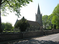
The parish includes the settlements of Goose Green, Tendring Green and Tendring Heath. The church is dedicated to St Edmund. The Tendring Union Workhouse was located at Tendring Heath.[3]
Transport
The village is on the B1035 road and close to the A120 road. There are bus services to Clacton-on-Sea and Colchester.
References
| ("Wikimedia Commons" has material about Tendring) |
- ↑ "Civil Parish population 2011". http://www.neighbourhood.statistics.gov.uk/dissemination/LeadKeyFigures.do?a=7&b=11129496&c=CO16+9AE&d=16&e=62&g=6426083&i=1001x1003x1032x1004&o=362&m=0&r=0&s=1443105898604&enc=1. Retrieved 24 September 2015.
- ↑ "TENDRING DISTRICT COUNCIL CONSERVATION AREA REVIEW". Tendring District Council. 2006. Archived from the original on 29 September 2011. http://webarchive.nationalarchives.gov.uk/20110929124422/http://www.tendringdc.gov.uk/NR/rdonlyres/E2CC4D5E-71C4-4C64-87E2-A2A9BD410758/1909/Tendringvillage.pdf. Retrieved 17 November 2011.
- ↑ Peter Higginbotham. "The Workhouse in Tendring, Essex". The Workhouse. http://www.workhouses.org.uk/Tendring/. Retrieved 17 November 2011.