Template:FP-Port Foster
From Wikishire
Revision as of 20:45, 23 July 2018 by RB (Talk | contribs) (Created page with "{{#switch:{{{1}}} |pic=XII Expedición Antártica 1957 - 1958.jpg |cap=Port Foster, British Antarctic Territory |text='''Port Foster''', one of the safest harbours in the Anta...")
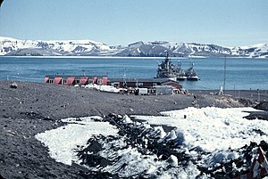
Port FosterPort Foster, one of the safest harbours in the Antarctic, is a natural sheltered harbour in the form of a great scoop out of the heart of Deception Island in the South Shetland Islands, part of the British Antarctic Territory. It is formed of a drowned and breached volcanic crater, of the volcano which created the island. The harbour was discovered by Nathaniel Palmer on 15 November 1820 and has been frequently visited by the ship of all nations since then. It was charted thoroughly by HMS Chanticleer in 1829. (Read more) |
