Difference between revisions of "Template:FP-Offa's Dyke"
From Wikishire
(Created page with "{{#switch:{{{1}}} |pic=Offa's Dyke near Clun.jpg |cap=Offa's Dyke near Clun, Shropshire |text=Offa's Dyke is a massive linear earthwork running north-south in a line once perh...") |
|||
| (2 intermediate revisions by the same user not shown) | |||
| Line 2: | Line 2: | ||
|pic=Offa's Dyke near Clun.jpg | |pic=Offa's Dyke near Clun.jpg | ||
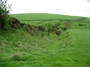
|cap=Offa's Dyke near Clun, Shropshire | |cap=Offa's Dyke near Clun, Shropshire | ||
| − | |text=Offa's Dyke is a massive linear earthwork running north-south in a line once perhaps | + | |text='''Offa's Dyke''' is a massive linear earthwork running north-south in a line once perhaps a hundred and fifty miles, roughly followed the boundary between England with Wales, which it was designed during the Dark Ages to mark border. In places, it is up to sixty-five feet wide (including its flanking ditch) and eight feet high. |
| − | The work is a defensive earthwork, consisting of a classic bank and ditch | + | The work is a defensive earthwork, consisting of a classic bank and ditch, created in the eighth century to form a delineation between the kingdoms of Mercia and Powys and it is attributed to King Offa, under whom Mercia reached the pinnacle of its power.}}<noinclude>{{FP data}} |
| − | + | ||
Latest revision as of 08:53, 9 May 2021
Offa's DykeOffa's Dyke is a massive linear earthwork running north-south in a line once perhaps a hundred and fifty miles, roughly followed the boundary between England with Wales, which it was designed during the Dark Ages to mark border. In places, it is up to sixty-five feet wide (including its flanking ditch) and eight feet high. The work is a defensive earthwork, consisting of a classic bank and ditch, created in the eighth century to form a delineation between the kingdoms of Mercia and Powys and it is attributed to King Offa, under whom Mercia reached the pinnacle of its power. (Read more) |
