Table Hill
| Table Hill | |||
| Herefordshire | |||
|---|---|---|---|
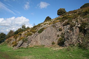
 Quarry on Table Hill | |||
| Range: | Malvern Hills | ||
| Summit: | 1,224 feet SO766464 | ||
Table Hill is in the range of Malvern Hills that runs approximately 8 miles north-south along the Herefordshire-Worcestershire border. Table Hill lies on the Herefordshire side of the ridge, between North Hill and Sugarloaf Hill and reaches a height of 1,224 feet.
Historical interest
The ancient flint route from Snowdonia to the West Country lay to the north of Malvern, but flint-bearing men, maybe traders, passed over the Malvern Hills. Parts of an arrowhead, a scraper and flint flakes have been discovered between North Hill and Table Hill.
A 19th-century guidebook describes both a collapsed burial mound on North Hill, named the Giant's Grave, and a tump on Table Hill. These tumuli may have been connected to the Dobunni settlement in Mathon, Herefordshire:[1]
Upon the Table Hill you will perceive the figure of a large table, whence the name is derived. In the centre is a cross, of the same size as that by the Giant's Grave, upon North Hill.[2]
References
- ↑ Smith, B.S: 1978 A History of Malvern Allan Sutton and The Malvern Bookshop ISBN 0904387313
- ↑ Southall, M: 1882 A Description of Malvern and its Concomitants