Difference between revisions of "Stronachlachar"
From Wikishire
m |
|||
| Line 2: | Line 2: | ||
|name=Stronachlachar | |name=Stronachlachar | ||
|county=Stirlingshire | |county=Stirlingshire | ||
| − | |picture= | + | |picture=Sròn a' Chlachair - Stronachlachar.JPG |
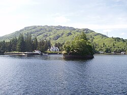
| − | |picture caption= | + | |picture caption=Stronachlachar from Loch Katrine |
|os grid ref=NN406102 | |os grid ref=NN406102 | ||
|latitude=56.257978 | |latitude=56.257978 | ||
| Line 19: | Line 19: | ||
The boundary of the [[Loch Lomond and the Trossachs]] National Park skirts around the edge of the village's outermost cottages. | The boundary of the [[Loch Lomond and the Trossachs]] National Park skirts around the edge of the village's outermost cottages. | ||
| − | + | {{stub}} | |
Revision as of 22:29, 14 July 2015
| Stronachlachar | |
| Stirlingshire | |
|---|---|
 Stronachlachar from Loch Katrine | |
| Location | |
| Grid reference: | NN406102 |
| Location: | 56°15’29"N, 4°34’27"W |
| Data | |
| Postcode: | FK8 |
| Local Government | |
| Council: | Stirling |
Stronachlachar is a lakeside hamlet of Stirlingshire, on the shore of Loch Katrine, on on the narrow neck of land between that loch and the smaller Loch Arklet to the west. It is at the end of a short lane off the narrow road along the loch and otherwise connected to the world only by water.
The boundary of the Loch Lomond and the Trossachs National Park skirts around the edge of the village's outermost cottages.
This Stirlingshire article is a stub: help to improve Wikishire by building it up.