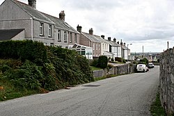
Stepaside, Cornwall
From Wikishire
Revision as of 09:12, 15 June 2019 by RB (Talk | contribs) (Created page with "{{Infobox town |name=Stepaside |county=Cornwall |picture=Roadside Houses - geograph.org.uk - 226394.jpg |picture caption=Clayworkers' houses at Stepaside |os grid ref=SW944544...")
| Stepaside | |
| Cornwall | |
|---|---|
 Clayworkers' houses at Stepaside | |
| Location | |
| Grid reference: | SW944544 |
| Location: | 50°21’13"N, 4°53’29"W |
| Data | |
| Local Government | |
Stepaside is a hamlet north of St Stephen-in-Brannel in mid Cornwall. This is a China-clay mining landscape: the hills north of the hamlet are scooped out by the workings and many of the houses here and in neighbouring Trethosa were built for those in the clay-working industry.