Difference between revisions of "Slieve Binnian"
(Created page with '{{Infobox hill |name=Slieve Binnian |county=County Down |range=Mourne Mountains |picture=NI Slieve Binnian.jpg |picture caption=Slieve Binnian |height=2,451 feet |os grid ref=J32…') |
|||
| Line 7: | Line 7: | ||
|height=2,451 feet | |height=2,451 feet | ||
|os grid ref=J320234 | |os grid ref=J320234 | ||
| + | |latitude=54.1422901 | ||
| + | |longitude=-5.9799001 | ||
}} | }} | ||
'''Slieve Binnian''' is in the [[Mourne Mountains]]. It is not the highest mountain in the Mournes but it is the most massive, and its high, tor-capped summit looms over the country all around. | '''Slieve Binnian''' is in the [[Mourne Mountains]]. It is not the highest mountain in the Mournes but it is the most massive, and its high, tor-capped summit looms over the country all around. | ||
| Line 14: | Line 16: | ||
The name of the mountain comes from the rocky tors situated around the top of the mountain. These very rugged crest of rocky tors makes it easy to identify in views around the [[Mourne Mountains]]. | The name of the mountain comes from the rocky tors situated around the top of the mountain. These very rugged crest of rocky tors makes it easy to identify in views around the [[Mourne Mountains]]. | ||
| − | To the south west of the mountain is [[Wee Binnian]] and to the west is the Silent Valley Reservoir. The [[Mourne Wall]] also crosses over Slieve Binnian. | + | To the south-west of the mountain is [[Wee Binnian]] and to the west is the Silent Valley Reservoir. The [[Mourne Wall]] also crosses over Slieve Binnian. |
The Binnian Tunnel was built in the late 1940s underneath Slieve Binnian, to transport water from the Annalong Valley to the Silent Valley. It took four years to construct, and two tunnelling teams started from opposite ends and met in the middle. Having been carefully measuring their positions the whole time, they found they were only two inches off course when the two tunnels met. | The Binnian Tunnel was built in the late 1940s underneath Slieve Binnian, to transport water from the Annalong Valley to the Silent Valley. It took four years to construct, and two tunnelling teams started from opposite ends and met in the middle. Having been carefully measuring their positions the whole time, they found they were only two inches off course when the two tunnels met. | ||
Latest revision as of 16:37, 28 August 2018
| Slieve Binnian | |||
| County Down | |||
|---|---|---|---|
 Slieve Binnian | |||
| Range: | Mourne Mountains | ||
| Summit: | 2,451 feet J320234 54°8’32"N, 5°58’48"W | ||
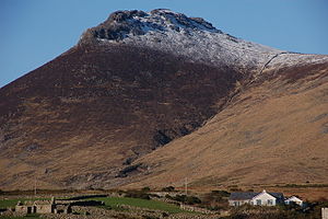
Slieve Binnian is in the Mourne Mountains. It is not the highest mountain in the Mournes but it is the most massive, and its high, tor-capped summit looms over the country all around.
This is the third-highest mountain in County Down (and all Ulster), rising to 2,451 feet
The name of the mountain comes from the rocky tors situated around the top of the mountain. These very rugged crest of rocky tors makes it easy to identify in views around the Mourne Mountains.
To the south-west of the mountain is Wee Binnian and to the west is the Silent Valley Reservoir. The Mourne Wall also crosses over Slieve Binnian.
The Binnian Tunnel was built in the late 1940s underneath Slieve Binnian, to transport water from the Annalong Valley to the Silent Valley. It took four years to construct, and two tunnelling teams started from opposite ends and met in the middle. Having been carefully measuring their positions the whole time, they found they were only two inches off course when the two tunnels met.