Difference between revisions of "Shilton, Warwickshire"
(Created page with "{{Infobox town |county=Warwick |name=Shilton |latitude=52.45606 |longitude=-1.40542 |LG district=Rugby |constituency=Rugby |post town=Coventry |postcode=CV7 |dialling code=02...") |
(No difference)
|
Latest revision as of 09:26, 30 January 2024
| Shilton | |
| Warwickshire | |
|---|---|
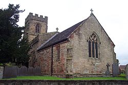
 St Andrew's Church | |
| Location | |
| Grid reference: | SP405844 |
| Location: | 52°27’22"N, 1°24’20"W |
| Data | |
| Post town: | Coventry |
| Postcode: | CV7 |
| Dialling code: | 024 |
| Local Government | |
| Council: | Rugby |
| Parliamentary constituency: |
Rugby |
Shilton is a village and ancient parish in the Knightlow hundred of Warwickshire. The village is about 5½ miles north-east of Coventry on the B4065 road and at a crossroads with the B4029 road, and is the same distance south-west of Hinckley. The village forms part of the civil parish of Shilton and Barnacle.
Shilton is almost cut in two by the Trent Valley railway line (part of the West Coast Main Line).[1] The village formerly had its own railway station on this line which opened in 1847, and closed in 1957.[2] A short distance to the north-west of the village is the M69 motorway.
The village contains a number of old cottages along the main street which were historically occupied by weavers, a village hall and one old pub, the "Shilton Arms", historically there was a second pub called the "Old Plough".[1]
The village was mentioned in the Domesday Book of 1086 as “Scelftone”, and was recorded as having eight households.[3][4] The parish church of St Andrew's has existed since the 13th century, but was rebuilt twice in the 14th and 15th centuries. A second north aisle was added in 1865, and was designed by Sir George Gilbert Scott.[5] The graveyard has some elaborately carved 18th century gravestones.[1] There is also a small baptist chapel in the village which dates from 1867.[6]
Leicester Road is just past the Shilton arms. Leicester Road contains a farm which field lies next to the Shilton Arms garden. As you enter Leicester Road on the left hand side there is a white house which used to be a pub too but was converted into a house in 2002.
References
| ("Wikimedia Commons" has material about Shilton, Warwickshire) |
- ↑ 1.0 1.1 1.2 Geoff, Allen (2000). Warwickshire Towns & Villages. Sigma Press. pp. 116–117. ISBN 1-85058-642-X.
- ↑ "Shilton Station". Warwickshire Railways. http://www.warwickshirerailways.com/lms/shilton.htm. Retrieved 24 October 2018.
- ↑ "Warwickshire Q-Z". The Domesday Book Online. http://www.domesdaybook.co.uk/warwickshire3.html. Retrieved 24 October 2018.
- ↑ "SHILTON". Our Warwickshire. https://www.ourwarwickshire.org.uk/content/location/shilton. Retrieved 24 October 2018.
- ↑ "CHURCH OF ST ANDREW, SHILTON". Our Warwickshire. https://www.ourwarwickshire.org.uk/content/catalogue_her/church-of-st-andrew-shilton. Retrieved 24 October 2018.
- ↑ "BAPTIST CHAPEL, CHURCH ROAD, SHILTON". Our Warwickshire. https://www.ourwarwickshire.org.uk/content/catalogue_her/baptist-chapel-church-road-shilton. Retrieved 24 October 2018.