Sheringham
| Sheringham | |
| Norfolk | |
|---|---|
.JPG) Town centre | |
| Location | |
| Grid reference: | TG1643 |
| Location: | 52°56’24"N, 1°12’47"E |
| Data | |
| Population: | 7,143 (2001) |
| Post town: | Sheringham |
| Postcode: | NR26 |
| Dialling code: | 01263 |
| Local Government | |
| Council: | North Norfolk |
| Parliamentary constituency: |
North Norfolk |
Sheringham is a seaside town on the north coast of Norfolk
Sheringham town centre is centred around a traditional high street with a wide range of privately owned shops. On Saturdays throughout the year there is a popular market in the car park next to the railway station which attracts large crowds even out of the holiday season. The town also has a good selection of specialist shops such as second-hand books, antiques and bric-a-brac, fishing tackle and bait, a computer shop, a model shop, and arts and craft shops. The Sheringham Little Theatre has a wide range of productions on throughout the year including a well-established summer repertory season running from July to September, and a popular pantomime at Christmas; in the foyer is a coffee shop with display of art by local artists. There is a selection of food outlets, pubs, restaurants, and a youth hostel.
The motto of the town, granted in 1953 to the Sheringham Urban District Council, is Mare Ditat Pinusque Decorat, Latin for "The sea enriches and the pine adorns".[1]
Contents
History
Historically, the parish of Sheringham comprised the two villages of Upper Sheringham, a farming community, and Lower Sheringham, which combined farming with fishing.
The fishing industry was at its peak in the late 19th and early 20th centuries, as the coming of the railways made it possible for fish to be transported more efficiently to market. Through the 1900s the focus of the fishing, as all along the north Norfolk coast, began to be on crabs, lobsters and whelks. The local fishermen were major suppliers of crabs and lobsters to the London fish markets. Long lining for cod and the catching of herring began to become less important in the second half of the century, as did whelking. Today, from a peak of maybe 200 boats, Sheringham has eight boats operated single-handed.
The current town of Sheringham was once Lower Sheringham, a fishing station for the main village, now known as Upper Sheringham. It is a railway town that was developed with the coming of the Midland and Great Northern Joint Railway line in the late 19th century. Most of Sheringham's range of buildings and shops come from this period and the early 20th century. It has a particularly interesting range of buildings using flint, not normally in the traditional Norfolk style but in a variety of techniques.
Events
An annual Cromer and Sheringham Crab/Lobster festival is held in May.[2]
Sheringham Museum
The town's museum now known as The Mo includes a collection of old lifeboats, various displays, a viewing tower and houses the Sheringham Shoal Offshore Wind Farm visitor centre.[3]
Lifeboats
Sheringham is reputed to be the only place in the world to have four of its original lifeboats.[4] The Sheringham Museum Trust owns three of these: JC Madge (1904–36) pulling and sailing, Foresters Centenary (1936–61) the town's first motorised lifeboat and Manchester Unity of Oddfellows (1961–90) an Oakley Class lifeboat, Sheringham’s last offshore boat.
Within the next two to three years Sheringham Museum Trust plans to have an extended museum to house this unique collection together with three crab boats and general lifeboat and fishing industry ephemera.
The town has no harbour, so the lifeboat has to be launched by tractor, and the fishing boats are hauled up the beach. An old sail-powered lifeboat is preserved in the former lifeboat shed and the three other preserved RNLI lifeboats are kept in another centre.
Railway
The railway line to Cromer and Norwich remains open as "the Bittern Line". Beyond Sheringham, the line has been preserved as the North Norfolk Railway also known as "The Poppy Line" to Holt.
About the town
Sheringham Hall and Park
In 1811, the Sheringham Estate was bought by Abbot and Charlotte Upcher. They asked Humphry Repton to design Sheringham Hall. The Upcher family also built a school. The Hall is still privately occupied, but Sheringham Park is in the care of the National Trust and open to visitors.
Other buildings of interest
- The Dales, formerly the residence of Henry Douglas King, M.P., and later Major William James Spurrell, D.S.O., M.C., is now a hotel (The Dales Country House).[5]
- Sheringham watermill was mainly known as a papermill that operated from around 1750 to about 1865, although it quite possibly started life as a corn mill and was powered by the small Beeston Beck. [6]
- Masonic Hall on Cromer Road. It was once the Electric Picture Palace.
The Oddfellows Hall
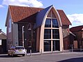
The Oddfellows Hall on the Lifeboat Plain, built in 1867, was the original RNLI Lifeboat station and a gathering place for fishermen and boat builders, and has over the years been used as a craft centre, used to exhibit a model railway, and to display a model village. The hall was also used as a shoe factory.
After years of standing idle, it re-opened in October 2007 having been completely refurbished at a cost of £250,000. A collection of taxpayer funded organizations and other interested parties worked together to facilitate the refurbishment of the hall and bring it back into community use.
Beeston Bump
Sheringham nestles under the nearby hill known as the Beeston Bump a geological "Site of Special Scientific Interest". It was the site of one of the Second World War secret Y-stations. The Bump can be climbed using the Norfolk Coast Path from either the east or west. The Bump began forming between 10,000 and 15,000 years ago at the end of the latest Ice Age: the huge mass of ice caused a depression in the land and, as the ice melted, the land mass began to 'spring' slowly back in a process called Isostatic readjustment, which process is still underway, the north of Great Britain rising slowly.
Beacon Hill
Beacon Hill, Norfolk's county top is just above Sheringham; a modest wooded hilltop overlooking the sea, but higher than any other place in the county. It is part of the estate owned by the National Trust.
The woodlands can be explored from paths running out of Beeston Regis and West Runton or from car parks on the hills.
Sea defences
The northern frontage of Sheringham is protected by a concrete seawall which also serves as the promenade. It is a vital part of the protection of the town against the natural erosion that occurs along the north Norfolk coast.
The storm surge of 1953 considerably damaged Sheringham's wooden sea defences. In front of the sea wall are groynes, armoured at their bases with large blocks of natural rock, which prevent long shore drift. There are numerous drains along the frontage. To the east towards West Runton the seawall ends just below Beeston Bump. From there a timber revetment and groyne system, designed and constructed in 1976, runs eastwards for just over a mile to West Runton Gap.
The Government's shoreline management plans include a policy of "managed retreat" along this stretch of coast. The revetment between Sheringham and West Runton is no longer being maintained and is thus in a poor state of repair. Sections that become hazardous will be removed. The coastline will then be left to evolve naturally.
Sport
- Football: Sheringham FC who play at Weybourne Road.
Pictures
The Oddfellows Hall
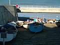
Fishing boats on slipway
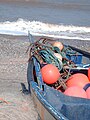
Fishing boat on beach
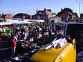
The Saturday market
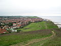
Sheringham from Beeston Bump


.JPG)

Outside links
| ("Wikimedia Commons" has material about Sheringham) |
References
- ↑ Town Crest and motto Retrieved 7 March 2013
- ↑ Crab Festival
- ↑ "Exporing the museum". The Mo: Sheringham Museum. http://www.sheringhammuseum.co.uk/the-museum. Retrieved 11 January 2011.
- ↑ http://www.sheringhammuseum.co.uk/museumlifeboats.html
- ↑ http://www.dalescountryhouse.co.uk/
- ↑ Norfolk Mills - Sheringham watermill