Rowstock
From Wikishire
Revision as of 18:52, 25 October 2011 by RB (Talk | contribs) (Created page with '{{Infobox town |name=Rowstock |county=Berkshire |picture=Rapeseed and Wheat Farmland near Rowstock and Harwell - geograph.org.uk - 10273.jpg |picture caption=Fields near Rowstoc…')
| Rowstock | |
| Berkshire | |
|---|---|
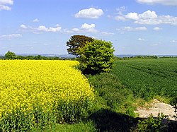
 Fields near Rowstock | |
| Location | |
| Grid reference: | SU478891 |
| Location: | 51°35’58"N, 1°18’37"W |
| Data | |
| Post town: | Didcot |
| Postcode: | OX11 |
| Dialling code: | 01235 |
| Local Government | |
| Council: | Vale of White Horse |
Rowstock is a hamlet in Berkshire 3 miles west of Didcot. It is gathered around the roundabout at the cross-roads of the A4130 and A417, between East Hendred to the west and Harwell to the east. The research park at Milton Hill lies to the north.
Rowstock is a place of farms, cottages and motor sale garages.
This Berkshire article is a stub: help to improve Wikishire by building it up.