Difference between revisions of "Ross, Northumberland"
From Wikishire
m |
m (Pic) |
||
| Line 2: | Line 2: | ||
|name=Ross | |name=Ross | ||
|county=Northumberland | |county=Northumberland | ||
| − | |picture= | + | |picture=Coastguard Cottages, Ross - geograph.org.uk - 153493.jpg |
| − | |picture caption= | + | |picture caption=Coastguard Cottages, Ross |
|os grid ref=NU132370 | |os grid ref=NU132370 | ||
|latitude=55.626802 | |latitude=55.626802 | ||
| Line 18: | Line 18: | ||
The north end of the Ross Back Sands form a finger of sand separated at high tide and reaching out toward the farther end of Lindisfarne, facing its harbour, almost to enclose the sheltered water behind. | The north end of the Ross Back Sands form a finger of sand separated at high tide and reaching out toward the farther end of Lindisfarne, facing its harbour, almost to enclose the sheltered water behind. | ||
| + | |||
| + | {{commons}} | ||
Latest revision as of 21:13, 1 March 2016
| Ross | |
| Northumberland | |
|---|---|
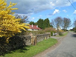
 Coastguard Cottages, Ross | |
| Location | |
| Grid reference: | NU132370 |
| Location: | 55°37’36"N, 1°47’27"W |
| Data | |
| Post town: | Belford |
| Postcode: | NE70 |
| Local Government | |
| Council: | Northumberland |
| Parliamentary constituency: |
Berwick-upon-Tweed |
Ross is a tiny hamlet in North Durham on the coast of northern Northumberland. It stands on a dead-end lane to the east of Elwick, on a low, flat peninsula between Buddle Bay and the gulf of sea and mudfalts which divides Lindisfarne from the county's mainland. A footpath leads out from the hamlet to the marshland of the Ross Links and the Ross Back Sands, a deep sandy beach on the coast of the open North Sea.
The north end of the Ross Back Sands form a finger of sand separated at high tide and reaching out toward the farther end of Lindisfarne, facing its harbour, almost to enclose the sheltered water behind.
| ("Wikimedia Commons" has material about Ross, Northumberland) |