Rainworth
| Rainworth | |
| Nottinghamshire | |
|---|---|
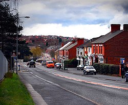
 Main road through Rainworth | |
| Location | |
| Grid reference: | SK590583 |
| Location: | 53°7’8"N, 1°7’7"W |
| Data | |
| Population: | 7,821 |
| Post town: | Mansfield |
| Postcode: | NG21 |
| Dialling code: | 01623 |
| Local Government | |
| Council: | Newark and Sherwood/ Mansfield |
| Parliamentary constituency: |
Mansfield / Sherwood |
Rainworth is a village in Nottinghamshire.
To the north of Rainworth is the village of Clipstone and to the east are the villages of Bilsthorpe and Farnsfield. Mansfield lies two miles to the west. The village of Blidworth is a mile to the south. The A617 dual-carriageway bypasses the village. The roundabout at the western terminus was the starting point for the Mansfield and Ashfield Regeneration Route. The former route through the village is the B6020.
Contents
Name
Local legend has it that the village is named after Rædwald King of the East Anglians, who stayed here in 617 AD before his victory in battle with against Æthelfrith King of the Mercians. In the battle, they say, Readwald's son, Regehere, was killed, and gave the area the name 'Regehere's Wath' (a wath being a ford or crossing point over a river).
Over the years, many changes in the spelling of the name have been recorded, from the original Regehere's Wath to Reynwath by 1268, then Raynwath, and then further adapted to the present day name of Rainworth.[1]
Locally, some pronounce the modern day spelling as 'Renneth'.[2]
History
Rainworth started as a settlement close to a Roman road that went through Mansfield and Newark and provided access to the coalfields of Derbyshire for the Roman settlements in the area to the east of Nottinghamshire. The sheltered location and access to clean water from the River Idle (now called Rainworth Water), meant that the area was often used by travelling Romans as a camp site.
Rainworth Lodge was first built in 1190 as a hunting lodge. Rufus Clarke lived there in 1212 and was with King John's hunting parties in the forest.
Little more is known about the village until the 16th century, when it is recorded that it was a peaceful hamlet with 13 dwellings:
- Three Thorn Hollow Farm;
- six houses in the Old Square known as Ramsden Croft;
- The original Robin Hood Inn, then named the Sherwood Inn;
- the toll house, nicknamed The Inkpot; and
- five houses on the road leading to Mansfield.
The people who lived in Rainworth were farmers or nurserymen.
Until the opening of the railway line linking Mansfield to Southwell in 1871 there was no public transport and the only way to get from place to place was to walk.
In 1879 an elm tree, later to be called the `Tree of Knowledge` was planted on the village green in front of the Robin Hood Inn. It became a favourite place for people to meet and talk. The tree eventually had to be cut down in 1962 when it became diseased.
In 1890 Rainworth's first church, a wooden building was built. However it was later replaced by a brick building which was opened on the festival day of St Simon and St Jude in 1939.
The building of the pumping station in 1895 meant that householders no longer had to get their water from wells and springs but from the pump outside the Robin Hood Inn.
In 1911, two mineshafts were sunk marking the start of work at Rufford Colliery. Only two years later the colliery suffered its worst pit disaster when 13 men were killed in an accident. As the pit prospered so the need for housing grew and new housing was built along Kirklington Road.
Blidworth and Rainworth railway station closed in 1965. Also along with many other pits in the area, Rufford Colliery stopped producing coal in 1993.
The colliery provided housing for approximately 400 families and leisure facilities such as a football ground and lido (which was in disuse by the end of the war), along with the Miners' Welfare. After over 80 years of service Rufford Colliery closed in 1993. The Miners' Welfare remains open, and has subsequent affiliations with the local football team and bowls club. In 1951, 40 council house had been completed, located on Kirklington Road, just beyond Python Hill School. A large housing estate was built in the 1950s, between Station Road and Warsop Lane (the Wimpey estate) and a further estate was built beyond the original council estate on Kirklington Road, at some time after 1965.
In literature
In The Widowing of Mrs Holroyd by D. H. Lawrence, Rainworth appears to as the childhood home of the orphaned Mrs Holroyd.
Lindhurst Wind Farm
Rainworth has a five turbine wind farm called Lindhurst Wind Farm which was built in 2010, the wind farm was controversial at the time of building.[3]
Media
The local paper covering the area is the Mansfield and Ashfield Chad which has a separate edition for the Sherwood area.
Outside links
| ("Wikimedia Commons" has material about Rainworth) |