Difference between revisions of "Preston-on-Stour"
From Wikishire
(Created page with "{{Infobox town |name=Preston-on-Stour |county=Gloucestershire |picture=Footpath to Atherstone on Stour - geograph.org.uk - 1735930.jpg |picture caption=Footpath to Atherston...") |
m |
||
| Line 3: | Line 3: | ||
|county=Gloucestershire | |county=Gloucestershire | ||
|picture=Footpath to Atherstone on Stour - geograph.org.uk - 1735930.jpg | |picture=Footpath to Atherstone on Stour - geograph.org.uk - 1735930.jpg | ||
| − | |picture caption=Footpath to | + | |picture caption=Footpath to Atherstone on Stour looking north |
|latitude=52.147343 | |latitude=52.147343 | ||
|longitude=-1.704180 | |longitude=-1.704180 | ||
| Line 15: | Line 15: | ||
|os grid ref=SP2023949981 | |os grid ref=SP2023949981 | ||
}} | }} | ||
| − | '''Preston-on-Stour''' is a village and parish in north-east [[Gloucestershire]], adjacent to the [[Warwickshire]] border. It is located some 2½ miles south of [[Stratford-on-Avon]] in the latter county. As the village name suggests the [[River Stour, Warwickshire|River Stour]] flows along its eastern fringe and the A3400 road runs about half-a-mile east. The village church is dedicated to Saint Mary.<ref>[http://mysite.wanadoo-members.co.uk/heartofengland/churches.htm Some pictures of St Mary's]</ref> The village did have an Infant and Junior School but this closed in 1974.<ref>{{cite web|url=http://www.nationalarchives.gov.uk/nra/searches/subjectView.asp?ID=O84880&tabType=ARCHIVE |title=The school on the National Archives website |publisher=Nationalarchives.gov.uk |date= |accessdate=2012-12-07}}</ref> The children's television show the | + | '''Preston-on-Stour''' is a village and parish in north-east [[Gloucestershire]], adjacent to the [[Warwickshire]] border. It is located some 2½ miles south of [[Stratford-on-Avon]] in the latter county. As the village name suggests the [[River Stour, Warwickshire|River Stour]] flows along its eastern fringe and the A3400 road runs about half-a-mile east. The village church is dedicated to Saint Mary.<ref>[http://mysite.wanadoo-members.co.uk/heartofengland/churches.htm Some pictures of St Mary's]</ref> The village did have an Infant and Junior School but this closed in 1974.<ref>{{cite web|url=http://www.nationalarchives.gov.uk/nra/searches/subjectView.asp?ID=O84880&tabType=ARCHIVE |title=The school on the National Archives website |publisher=Nationalarchives.gov.uk |date= |accessdate=2012-12-07}}</ref> The children's television show the ''Teletubbies'' was filmed about 1¼ miles south of the village. |
| + | |||
| + | ==Outside links== | ||
| + | {{commons}} | ||
==References== | ==References== | ||
{{reflist}} | {{reflist}} | ||
| − | |||
| − | |||
| − | |||
{{stub}} | {{stub}} | ||
Revision as of 20:39, 9 November 2016
| Preston-on-Stour | |
| Gloucestershire | |
|---|---|
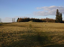
 Footpath to Atherstone on Stour looking north | |
| Location | |
| Grid reference: | SP2023949981 |
| Location: | 52°8’50"N, 1°42’15"W |
| Data | |
| Post town: | Stratford-upon-Avon |
| Postcode: | CV37 |
| Dialling code: | 01789 |
| Local Government | |
| Council: | Stratford-on-Avon |
| Parliamentary constituency: |
Stratford-on-Avon |
Preston-on-Stour is a village and parish in north-east Gloucestershire, adjacent to the Warwickshire border. It is located some 2½ miles south of Stratford-on-Avon in the latter county. As the village name suggests the River Stour flows along its eastern fringe and the A3400 road runs about half-a-mile east. The village church is dedicated to Saint Mary.[1] The village did have an Infant and Junior School but this closed in 1974.[2] The children's television show the Teletubbies was filmed about 1¼ miles south of the village.
Outside links
| ("Wikimedia Commons" has material about Preston-on-Stour) |
References
- ↑ Some pictures of St Mary's
- ↑ "The school on the National Archives website". Nationalarchives.gov.uk. http://www.nationalarchives.gov.uk/nra/searches/subjectView.asp?ID=O84880&tabType=ARCHIVE. Retrieved 2012-12-07.