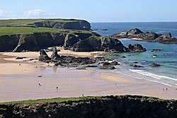
Porthcothan
From Wikishire
Revision as of 20:09, 23 September 2016 by RB (Talk | contribs) (Created page with "{{Infobox town |name=Porthcothan |cornish=Porthkehodhon |county=Cornwall |picture=Porthcothan Beach - geograph.org.uk - 314452.jpg |picture caption=Porthcothan Beach |os grid...")
| Porthcothan Cornish: Porthkehodhon | |
| Cornwall | |
|---|---|
 Porthcothan Beach | |
| Location | |
| Grid reference: | SW719858 |
| Location: | 50°30’29"N, 5°1’20"W |
| Data | |
| Post town: | Padstow |
| Postcode: | PL28 |
| Dialling code: | 01841 |
| Local Government | |
| Council: | Cornwall |
| Parliamentary constituency: |
North Cornwall |
Porthcothan is a coastal village between Newquay and Padstow in Cornwall. It is close by St Eval and within its civil parish.
Porthcothan is within the 'Cornwall Area of Outstanding Natural Beauty', as is almost a third of the county.
The sandy beach is popular with tourists and surfers and is patrolled by lifeguards during the day in the summer; local surf schools sometimes use the beach for tuition. There is a pay-and-display car park and a small grocery shop near the beach.
In January 2014, Storm Anne reduced a local arch, Jan Leverton's Rock, to rubble.[1][2]
Outside links
| ("Wikimedia Commons" has material about Porthcothan) |
References
- ↑ "UK storms: Further flooding risk as heavy rain forecast". BBC News. 7 January 2014. http://www.bbc.co.uk/news/uk-25633693. Retrieved 7 January 2014.
- ↑ "Storms smash iconic Cornish rock formation at Porthcothan". Western Morning News. 7 January 2014. http://www.westernmorningnews.co.uk/Storms-smash-iconic-Cornish-rock-formation/story-20405815-detail/story.html. Retrieved 7 January 2014.