Difference between revisions of "Pilot Hill"
m (Created page with '{{Infobox hill |name=Pilot Hill |county=Hampshire |picture=Pilot Hill - geograph.org.uk - 403564.jpg |picture caption=Pilot Hill from the south side |height=938 feet |range= |os …') |
|||
| Line 8: | Line 8: | ||
|os grid ref=SU398601 | |os grid ref=SU398601 | ||
}} | }} | ||
| − | '''Pilot Hill''' is a hill in northern [[Hampshire]] | + | '''Pilot Hill''' is a hill in northern [[Hampshire]] which climbs to 938 feet. It is part of the scarp of the North Hampshire Downs, a chalk ridge within the North Wessex Downs Area of Outstanding Natural Beauty and to the north down the escarpment a fine view opens up across the farmland around [[East Woodhay]] and far beyond. |
| − | The | + | The upper slopes are open, chalky grassland, while the lower slopes are wooded. |
| − | The | + | The summit of Pilot Hill, marked with a trig point in a field, is the second-highest point in Hampshire though the highest hill excludsively in the county; Hampshire's actual [[county top]] is at [[Walbury Hill]] just over a mile away, which hill is divided between Hampshire and [[Berkshire]]. The two are joined by the Wayfarer's Path, a long-distance footpath which follows the top of the ridge of the Downs. |
| − | + | ||
| − | + | ||
| − | + | ||
| − | + | ||
Revision as of 09:28, 31 May 2012
| Pilot Hill | |
| Hampshire | |
|---|---|
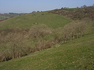
 Pilot Hill from the south side | |
| Summit: | 938 feet SU398601 |
Pilot Hill is a hill in northern Hampshire which climbs to 938 feet. It is part of the scarp of the North Hampshire Downs, a chalk ridge within the North Wessex Downs Area of Outstanding Natural Beauty and to the north down the escarpment a fine view opens up across the farmland around East Woodhay and far beyond.
The upper slopes are open, chalky grassland, while the lower slopes are wooded.
The summit of Pilot Hill, marked with a trig point in a field, is the second-highest point in Hampshire though the highest hill excludsively in the county; Hampshire's actual county top is at Walbury Hill just over a mile away, which hill is divided between Hampshire and Berkshire. The two are joined by the Wayfarer's Path, a long-distance footpath which follows the top of the ridge of the Downs.