New Addington
| New Addington | |
| Surrey | |
|---|---|
 Central Parade | |
| Location | |
| Grid reference: | TQ382622 |
| Location: | 51°20’34"N, 0°1’0"W |
| Data | |
| Population: | 22,280 (2011) |
| Post town: | Croydon |
| Postcode: | CR0 |
| Dialling code: | 01689 |
| Local Government | |
| Parliamentary constituency: |
Croydon Central |
New Addington forms the southern part of the ancient parish of Addington in metropolitan Surrey, adjacent to the border with Kent. It is a large local authority estate surrounded by the Metropolitan Green Belt of open countryside, woodland and golf courses. The Prime Meridian crosses the eastern edge of New Addington.
The area's isolation from the rest of the Croydon borough has given it a strong sense of community and independence. The Croydon Advertiser publishes a separate New Addington edition. The presence of the library, youth clubs, leisure centre, shops, churches and street market enables locals to lead full lives in many ways. The Addington Community Association has provided an important hub for the community. It has been notable for its local gangs.
History
Until the 1930s, the area now known as New Addington was farmland and woodland. The farms were called Castle Hill, Addington Lodge and Fisher's Farms.[1] At the time, central Croydon and London more generally had overcrowded slums causing concern to the authorities. In 1935, the First National Housing Trust purchased 569 acres of Fisher's Farm with the intention of erecting a 'Garden Village', with 4,400 houses, shops, two churches, cinema, and village green. The Chairman of the Trust was Charles Boot, hence the earliest part of New Addington is sometimes called The Boot's Estate.[1]
By 1939, when the outbreak of World War II suspended construction, 1,023 houses and 23 shops had been built. The new estate was popular, but the provision of amenities had not kept pace with the house building. Only one of the proposed schools and few of the shops were in operation. For employment, decent shopping and entertainment, the residents had to travel off the estate. This heralded a long history of isolation for the estate, then nicknamed Little Siberia, because it is much colder than the rest of Croydon. The isolation was partly remedied 60 years later with the arrival of Tramlink. The trams run alongside Lodge Lane, the main (northern) road access. There is only one other point of access by road, where King Henry's Drive connects with minor roads to the south.
After the war, there were concerns about the amount of green space being used for building around London. Much of the countryside around the developing estate was declared Green Belt. The Croydon Corporation bought the unused First National Housing Trust land and a further 400 acres to add to it, for extensive further development. Many dozens of single-storey, detached, prefabricated houses (commonly known as "prefabs" as photographed in "A 1950s metal UK prefab at the Rural Life Centre, Tilford, Surrey.") were built in the Castle Hill area of the estate and these were inhabited until the 1960s when they were demolished and replaced with brick-built two-storey homes. At the same time as the smaller prefabs were built, larger two-storey semi-detached houses were also built. These houses, which had metal upper skins, still survive around the King Henry's Drive area near Wolsey School. This was more development than had originally been envisaged but it brought about the structure of the estate as seen today.
Many more houses, blocks of flats, churches, factories and Central Parade with its shops, were built. The Council obtained permission for a further 1,412 houses, which were completed in 1968. This area, at the Croydon end, is known as the Fieldway Estate and has developed its own identity to an extent.[1] The total population counted by the 2011 Census was 22,280, of which 10,801 were in New Addington ward, with 11,479 in Fieldway ward.
The distance from Croydon and other centres, with for many years patchy bus services the only main transport links prevented New Addington residents from being able to access a full range of employment and educational facilities or indeed shops. A significant improvement was the arrival of Tramlink (route 3) in 2000, providing a connection with Croydon and Wimbledon in a little over 30 minutes, and from there connections to Central London. This provided the opportunity of a greater choice of schools and jobs. Several 'feeder' 'bus routes were also introduced to connect with Tramlink, along with general enhancement to 'bus services in the area. The area was declared one of the first Education Action Zones by the government, with extra investment and opportunities for partnership for schools. The Council increased its investment in the remaining housing stock and in the leisure and youth facilities. It also organised a neighbourhood partnership for the estate which local people lead to hold public institutions to account.
Facilities
The Anglican parish church of New Addington is St Edward's Church at the end of Central Parade, built in 1957. Fieldway, however, is part of Addington ecclesiastical parish, under the 11th century St Mary the Blessed Virgin Church in Addington village. There are also a Baptist church, the Good Shepherd Roman Catholic Church, the Salvation Army and several other smaller places of worship.
Transport
New Addington is served by several Transport for London bus services giving it links with Croydon, Bromley, Eltham and Selsdon.
There are also Tramlink services to Wimbledon via Croydon.
Gallery
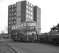
Bus route 130B on its first day of service in 1985
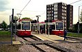
The tram terminus on the first day of service, 2000
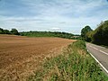
Jewels Wood, between New Addington and Biggin Hill
The Man on the Moon pub
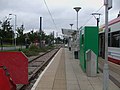
New Addington tram stop
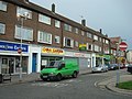
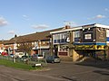
Central Parade


