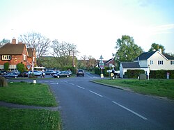
Milland
From Wikishire
Revision as of 20:25, 24 January 2023 by RB (Talk | contribs) (Created page with "{{Infobox town |name=Milland |county=Sussex |picture=Milland Crossroads.JPG |picture caption=Milland Crossroads |os grid ref=SU838269 |latitude=51.03601 |longitude=-0.80607 |p...")
| Milland | |
| Sussex | |
|---|---|
 Milland Crossroads | |
| Location | |
| Grid reference: | SU838269 |
| Location: | 51°2’10"N, 0°48’22"W |
| Data | |
| Population: | 891 (2011) |
| Post town: | Liphook |
| Postcode: | GU30 |
| Dialling code: | 01428 |
| Local Government | |
| Council: | Chichester |
| Parliamentary constituency: |
Chichester |
| Website: | http://www.milland-pc.gov.uk/ |
Milland is a village in Sussex, sitting at a crossroads on a local lane which was in ages past a Roman road, in the north-westernmost part of the county close to the border with Hampshire.
The 2011 census recorded a parish population of 891.
The village lies along a section of the Chichester to Silchester Way Roman road, almost the only part to have survived in modern use. At the southern end of the village the boundary banks of a mansio, a Roman posting station on the road, are visible.[1][2]
Churches
- Church of England: St Luke's
- Independent / Evangelical: Milland Evangelical Church
The disused Tuxlith Chapel is in the care of a national charity the Friends of Friendless Churches.
Outside links
| ("Wikimedia Commons" has material about Milland) |
References
- ↑ Margary, Ivan D. (1968). Roman ways in the Weald. Phoenix house. ISBN 978-0-460-07742-2. https://books.google.com/books?id=UzW7AAAACAAJ&printsec=frontcover&dq=editions:OCLC154129547.
- ↑ Petersfield Museum-section on roads Template:Webarchive