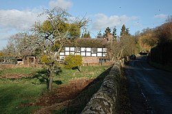
Mansell Gamage
From Wikishire
Revision as of 20:46, 4 September 2019 by RB (Talk | contribs) (Created page with "{{Infobox town |name=Mansell Gamage |county=Herefordshire |picture=Cottage in Mansell Gamage - geograph.org.uk - 316250.jpg |picture caption=Cottage in Mansell Gamage |os grid...")
| Mansell Gamage | |
| Herefordshire | |
|---|---|
 Cottage in Mansell Gamage | |
| Location | |
| Grid reference: | SO393447 |
| Location: | 52°5’51"N, 2°53’12"W |
| Data | |
| Postcode: | HR4 |
| Local Government | |
| Council: | Herefordshire |
Mansell Gamage is a hamlet in Herefordshire,[1] on the slope of a little, sudden, wooded hill known as Garnon's Hill on the north side of the River Wye. A section of Offa's Dyke runs up the hill, leaving Mansell Gamage on the west side of the dyke.
The course of a Roman road runs just south of the hamlet, following the Wye valley up from Magnae Dobunnorum (Kenchester) and the Three Rivers Ride route lops f-round the hill and through the hamlet.
Mansell Gamage is on the B4230 road and is near the A438 Hereford to Brecon road.
References
- ↑ "History of Mansell Gamage in Herefordshire". A Vision of Britain Through Time. University of Portsmouth. 2009. http://www.visionofbritain.org.uk/place/place_page.jsp?p_id=3510. Retrieved 15 April 2012.