Difference between revisions of "Malmsmead Bridge"
From Wikishire
(Created page with "{{Infobox bridge |name=Malmsmead Bridge |county 1=Devon |county 2=Somerset |picture=Malmsmead Bridge over Badgworthy Water (geograph 3002984).jpg |picture caption=Malmsmead Br...") |
m (→top: ioe -> nhle, replaced: {{IoE|265451 → {{NHLE|1173396) |
||
| (One intermediate revision by one other user not shown) | |||
| Line 22: | Line 22: | ||
'''Malmsmead Bridge''' is a 17th-century stone bridge which crosses the [[Badgworthy Water]] between [[Devon]] on the western bank and [[Somerset]] on the eastern in the hamlet of [[Malmsmead]]. It carries the road between [[Oare, Somerset|Oare]] and [[Brendon]]. Both banks are within the [[Exmoor]] National Park. | '''Malmsmead Bridge''' is a 17th-century stone bridge which crosses the [[Badgworthy Water]] between [[Devon]] on the western bank and [[Somerset]] on the eastern in the hamlet of [[Malmsmead]]. It carries the road between [[Oare, Somerset|Oare]] and [[Brendon]]. Both banks are within the [[Exmoor]] National Park. | ||
| − | The bridge has been scheduled as an ancient monument and is a Grade II listed structure.<ref>{{pastscape|35099|Malmsmead Bridge}}</ref><ref name=IoE>{{ | + | The bridge has been scheduled as an ancient monument and is a Grade II listed structure.<ref>{{pastscape|35099|Malmsmead Bridge}}</ref><ref name=IoE>{{NHLE|1173396|Malmsmead Bridge}}</ref> |
The bridge has two round arches each of which is eight feet six inches wide.<ref>{{NHLE|1289346|Malmsmead Bridge}}</ref><ref>{{cite web|title=MSO7729 - Malmsmead Bridge|url=http://www.exmoorher.co.uk/hbsmr-web/record.aspx?uid=MSO7729-Malmsmead-Bridge-|website=Exmoor National Park Historic Environment Record|publisher=Exmoor National Park|accessdate=7 March 2015}}</ref> | The bridge has two round arches each of which is eight feet six inches wide.<ref>{{NHLE|1289346|Malmsmead Bridge}}</ref><ref>{{cite web|title=MSO7729 - Malmsmead Bridge|url=http://www.exmoorher.co.uk/hbsmr-web/record.aspx?uid=MSO7729-Malmsmead-Bridge-|website=Exmoor National Park Historic Environment Record|publisher=Exmoor National Park|accessdate=7 March 2015}}</ref> | ||
| Line 31: | Line 31: | ||
==References== | ==References== | ||
{{reflist}} | {{reflist}} | ||
| − | |||
| − | |||
Latest revision as of 08:27, 19 September 2019
| Malmsmead Bridge | |
| Devon, Somerset | |
|---|---|
 Malmsmead Bridge | |
| Location | |
| Type: | Packhorse bridge |
| Crossing: | Badgworthy Water |
| Location | |
| Grid reference: | SS79194773 |
| Location: | 51°12’57"N, 3°43’52"W |
| Structure | |
| Type: | Packhorse bridge |
| Design: | Arch bridge |
| Material: | Stone |
| History | |
| Built 17th century | |
| Information | |
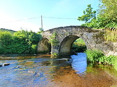
Malmsmead Bridge is a 17th-century stone bridge which crosses the Badgworthy Water between Devon on the western bank and Somerset on the eastern in the hamlet of Malmsmead. It carries the road between Oare and Brendon. Both banks are within the Exmoor National Park.
The bridge has been scheduled as an ancient monument and is a Grade II listed structure.[1][2]
The bridge has two round arches each of which is eight feet six inches wide.[3][4]
Outside links
| ("Wikimedia Commons" has material about Malmsmead Bridge) |
References
- ↑ National Monuments Record: No. 35099 – Malmsmead Bridge
- ↑ National Heritage List 1173396: Malmsmead Bridge
- ↑ National Heritage List 1289346: Malmsmead Bridge
- ↑ "MSO7729 - Malmsmead Bridge". Exmoor National Park. http://www.exmoorher.co.uk/hbsmr-web/record.aspx?uid=MSO7729-Malmsmead-Bridge-. Retrieved 7 March 2015.