Difference between revisions of "Lyddington"
(Created page with "{{Infobox town |county=Rutland |picture=Lyddington.jpg |picture caption=The road into Lyddington from the south |population = 397 |census year=2001<ref>{{cite web |url=http://...") |
|||
| Line 16: | Line 16: | ||
'''Lyddington''' is a village and parish in southern [[Rutland]] adjacent to the border with [[Northamptonshire]]. The population of the civil parish was 397 at the 2001 census, falling to 366 at the 2011 census.<ref>{{cite web|url=http://www.neighbourhood.statistics.gov.uk/dissemination/LeadKeyFigures.do?a=7&b=11126183&c=Lyddington&d=16&e=62&g=6384753&i=1001x1003x1032x1004&m=0&r=1&s=1466851102971&enc=1|title=Civil Parish population 2011|accessdate=25 June 2016|publisher=Office for National Statistics|work=Neighbourhood Statistics}}</ref> | '''Lyddington''' is a village and parish in southern [[Rutland]] adjacent to the border with [[Northamptonshire]]. The population of the civil parish was 397 at the 2001 census, falling to 366 at the 2011 census.<ref>{{cite web|url=http://www.neighbourhood.statistics.gov.uk/dissemination/LeadKeyFigures.do?a=7&b=11126183&c=Lyddington&d=16&e=62&g=6384753&i=1001x1003x1032x1004&m=0&r=1&s=1466851102971&enc=1|title=Civil Parish population 2011|accessdate=25 June 2016|publisher=Office for National Statistics|work=Neighbourhood Statistics}}</ref> | ||
| − | [[Lyddington Bede House]], owned by [[English Heritage]], is a Grade-I-listed building<ref>{{NHLE |num=1264528 |desc=The Bedehouse}}</ref> incorporating parts of a | + | [[Lyddington Bede House]], owned by [[English Heritage]], is a Grade-I-listed building<ref>{{NHLE |num=1264528 |desc=The Bedehouse}}</ref> incorporating parts of a mediæval bishop's palace. In 1547 it was seized on behalf of the king from the Bishops of Lincoln and later passed to Lord Burghley. In 1600 part of the palace was converted into an almshouse and it continued in this use until 1930. The remains of the fishponds of the bishop's palace are nearby. |
The parish church of St Andrew is also a Grade-I-listed building.<ref>{{NHLE |num=1236656 |desc=Church of Saint Andrew, Church Lane}}</ref> | The parish church of St Andrew is also a Grade-I-listed building.<ref>{{NHLE |num=1236656 |desc=Church of Saint Andrew, Church Lane}}</ref> | ||
| Line 29: | Line 29: | ||
==References== | ==References== | ||
| − | |||
{{Commons}} | {{Commons}} | ||
| + | {{reflist}} | ||
{{stub}} | {{stub}} | ||
Latest revision as of 19:52, 11 September 2016
| Lyddington | |
| Rutland | |
|---|---|
 The road into Lyddington from the south | |
| Location | |
| Grid reference: | SP875969 |
| Location: | 52°33’47"N, 0°42’32"W |
| Data | |
| Population: | 397 (2001[1]) |
| Post town: | Oakham |
| Postcode: | LE15 |
| Dialling code: | 01572 |
| Local Government | |
| Council: | Rutland |
| Parliamentary constituency: |
Rutland and Melton |
Lyddington is a village and parish in southern Rutland adjacent to the border with Northamptonshire. The population of the civil parish was 397 at the 2001 census, falling to 366 at the 2011 census.[2]
Lyddington Bede House, owned by English Heritage, is a Grade-I-listed building[3] incorporating parts of a mediæval bishop's palace. In 1547 it was seized on behalf of the king from the Bishops of Lincoln and later passed to Lord Burghley. In 1600 part of the palace was converted into an almshouse and it continued in this use until 1930. The remains of the fishponds of the bishop's palace are nearby.
The parish church of St Andrew is also a Grade-I-listed building.[4]
There are two public houses, The Marquess of Exeter and The Old White Hart.
Gallery
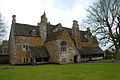
The Bedehouse
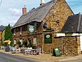
The Marquess of Exeter Hotel


References
| ("Wikimedia Commons" has material about Lyddington) |
- ↑ "Rutland Civil Parish Populations". Rutland County Council. 2001. http://www.rutland.gov.uk/ppimageupload/Image27657.PDF. Retrieved 15 March 2009.
- ↑ "Civil Parish population 2011". Neighbourhood Statistics. Office for National Statistics. http://www.neighbourhood.statistics.gov.uk/dissemination/LeadKeyFigures.do?a=7&b=11126183&c=Lyddington&d=16&e=62&g=6384753&i=1001x1003x1032x1004&m=0&r=1&s=1466851102971&enc=1. Retrieved 25 June 2016.
- ↑ National Heritage List 1264528: The Bedehouse
- ↑ National Heritage List 1236656: Church of Saint Andrew, Church Lane