Loch a' Bhraoin

Loch a' Bhraoin, or Loch Broom (meaing 'Lake of showers or drizziling rain'),[1] is a freshwater loch of 415 acres in Wester Ross, within Ross-shire,[2] and with the south-western end of the loch intruding its south bank into the Fannichs area of Cromartyshire.
The main A832 road that is part of the 'Wester Ross Coastal Trail', leaves the main A835 road, at the Falls of Measach and passes the eastern end of the loch.
Walking
Loch a' Bhraoin is considered an excellent location for walkers.[3] There are essentially four routes into the mountains surrounding Loch a' Bhraoin. The main route is from the A832 road, taking the path east to west along Destitution Road to Loch a’ Bhraoin from the East. Also travelling from Poolewe past the Fionn Loch in the north-west, which is the longest route. Travelling from Incheril over the Heights of Kinlochewe and the Kinlochewe Forest in the SW, and from Corrie Hallie that directly north of the loch.
Geography

Loch a' Bhraoin lies about seven miles to the south of the head of Loch Broom, the sea-loch of that name, and is surrounded by high hills.[2] At the west end of the loch, about two miles from the end of the loch is the plateau of a' Chailleach that rises to 3,276 feet above sea level. The loch is orientated on a north-east to south-west direction and is over two and a half miles in length. The maximum breadth of the loch is about 850 yards wide.[2]
On a north by northeast direction from a' Chailleach, the mountains have been folded extensively. Two corries overlook Loch a' Bhraoin to the north. The first of these is formed by the mountain @Toman Còinnich at 3,068 feet, which forms the corrie that contains Loch Toll an Lochain, where the direction of the corrie faces the northern end of the loch, similar to a giants seat. Further east again, is Sgurr Breac, which forms the peak of the second fold, which creates the corrie, that is intersected by a long shallow valley that descends from 1,970 feet down to the north-east end of the loch.[2]
On the northern end of the loch, there is several small hills, that make a shallow cliff which follows the curve of the loch. Overlooking the southwest end of the loch, is Creag Rainich at 2,648 feet and Meall Dubh at 2,454 feet comprising two hills. Further up the loch, both Bristeadh á Mhill Dhubh at 1,824 feet and Meall an t-Sìthe at 1,972 feet make up the main peaks of the show curve that follows the curve of the loch.
Pictures
Looking west over Loch a' Bhraoin.

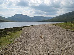
Heading north east along the shore of this loch.

The loch with Slioch poking out behind Beinn Bheag behind

With the Fisherfield Hills beyond

Looking up the loch from near its outflow to Slioch and Mullach Coire Mhic Fhearchair
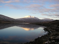
Groban, reflected in Loch a' Bhraoin

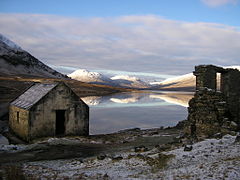
Ruin and Boathouse on Loch a' Bhraoin
Groban and Beinn Bheag, reflected in the loch

The east end of Loch a' Bhraoin
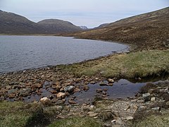
One of the many fords across the small burns feeding the loch


.jpg)


Location
- Location map: 57°43’12"N, 5°7’57"W
Outside links
References
- ↑ Robertson, James Alexander: 'The Gaelic Topography of Scotland, and what it Proves: Explained, with Much Historical, Antiquarian and Descriptive Information' (W.P. Nimmo, 1869)
- ↑ 2.0 2.1 2.2 2.3 Murray, John; Pullar, Laurence: 'https://maps.nls.uk/bathymetric/chart/2163 Bathymetrical Survey of the Fresh-Water Lochs of Scotland, 1897-1909]': NLS
- ↑ Howie, Robin (28 October 2012). "Walk of the week: Loch a’Bhraoin". The Scotsman. https://www.scotsman.com/news/walk-of-the-week-loch-a-bhraoin-1-2603169. Retrieved 6 May 2018.
- Loch a' Bhraoin: British Lakes