Llanfihangel-yn-Nhowyn
From Wikishire
Revision as of 12:30, 3 September 2019 by Owain (Talk | contribs) (Created page with "{{infobox town |county=Anglesey |picture=The Anglican church of St Michael's in the Dune - geograph.org.uk - 760894.jpg |latitude=53.26712 |longitude=-4.51872 |post town=Holyh...")
| Llanfihangel-yn-Nhowyn | |
| Anglesey | |
|---|---|

| |
| Location | |
| Location: | 53°16’2"N, 4°31’7"W |
| Data | |
| Post town: | Holyhead |
| Postcode: | LL65 |
| Local Government | |
| Council: | Anglesey |
| Parliamentary constituency: |
Ynys Môn |
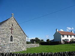
Llanfihangel yn Nhowyn is a village and ancient parish in the in Llyfon hundred of Anglesey. The church in the village, St Michael's, is a Grade-II listed building and is the chapel for the nearby airbase, RAF Valley.[1]
References
- ↑ Cadw (2009). "Church of St Mihangel". Historic Wales. http://jura.rcahms.gov.uk/cadw/cadw_eng.php?id=5309. Retrieved 11 June 2013.