Difference between revisions of "Little Downham"
(Created page with '{{Infobox town |name=Little Downham |county=Cambridgeshire |picture=Village sign in Little Downham - geograph.org.uk - 1764348.jpg |picture caption=Village sign in Little Downha…') |
m |
||
| (One intermediate revision by the same user not shown) | |||
| Line 3: | Line 3: | ||
|county=Cambridgeshire | |county=Cambridgeshire | ||
|picture=Village sign in Little Downham - geograph.org.uk - 1764348.jpg | |picture=Village sign in Little Downham - geograph.org.uk - 1764348.jpg | ||
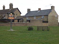
| − | |picture caption= | + | |picture caption=Green in Little Downham |
|os grid ref=TL518841 | |os grid ref=TL518841 | ||
|latitude=52.433 | |latitude=52.433 | ||
| Line 14: | Line 14: | ||
'''Little Downham''' is a village in [[Cambridgeshire]], within the [[Isle of Ely]]. It stands just 3 miles north of the pocket-sized City of [[Ely]], and its parish includes the hamlet of [[Pymoor]]. It has an approximate population of 2660 with approximately 35 miles for footpaths around the parish.<ref>[http://visitely.eastcambs.gov.uk/focus-on-the-fens/little-downham "Visit Ely" Website]</ref> | '''Little Downham''' is a village in [[Cambridgeshire]], within the [[Isle of Ely]]. It stands just 3 miles north of the pocket-sized City of [[Ely]], and its parish includes the hamlet of [[Pymoor]]. It has an approximate population of 2660 with approximately 35 miles for footpaths around the parish.<ref>[http://visitely.eastcambs.gov.uk/focus-on-the-fens/little-downham "Visit Ely" Website]</ref> | ||
| − | + | In the [[Domesday Book]] the village is called ''Duneham''. At the time the [[Great Fen|Fenlands]] were mostly flooded, and the village is on a small rise of solid ground (visible today), suggesting its name form its low "down" or hill. | |
| − | In the [[Domesday Book]] the village is called Duneham. At the time the [[Great Fen]] were mostly flooded, and the village is on a small rise of solid ground (visible today), | + | |
==Local Nature Reserve== | ==Local Nature Reserve== | ||
Latest revision as of 22:59, 16 July 2013
| Little Downham | |
| Cambridgeshire | |
|---|---|
 Green in Little Downham | |
| Location | |
| Grid reference: | TL518841 |
| Location: | 52°25’59"N, 0°13’59"E |
| Data | |
| Local Government | |
| Council: | East Cambridgeshire |
Little Downham is a village in Cambridgeshire, within the Isle of Ely. It stands just 3 miles north of the pocket-sized City of Ely, and its parish includes the hamlet of Pymoor. It has an approximate population of 2660 with approximately 35 miles for footpaths around the parish.[1]
In the Domesday Book the village is called Duneham. At the time the Fenlands were mostly flooded, and the village is on a small rise of solid ground (visible today), suggesting its name form its low "down" or hill.
Local Nature Reserve
Little Downham has the first dedicated Local Nature Reserve in the area, which is situated adjacent to the Bishop's walk. It consists of four sections of land, measuring a total of 17 acres.
Local Events
- Village fete in June
- Mediæval Fair in June, held just outside of the village
- Scarecrow Fair In September, held by the local primary school: the village lined with scarecrows for the week building up to the fair.
- Ely New Year's Eve 10k Race, organised by Ely Runners, both begins and ends in Little Downham. The 2011 race featured 700 runners and involved one circuit of the fen around Little Downham.[2]
Little Downham Recreation Ground on School Lane has been given the status of a Queen Elizabeth II Field.
Outside links
| ("Wikimedia Commons" has material about Little Downham) |
- Little Downham Scarecrow Week 2011
- Little Downham Mediæval Fair 2011
- Little Downham Village Fete 2011
- Little Downham - Ely On-line
- Little Downham Parish Community Website
- CCAN web page
