Difference between revisions of "Laity Moor"
From Wikishire
| Line 4: | Line 4: | ||
|picture=Chapel at Laity Moor - geograph.org.uk - 161020.jpg | |picture=Chapel at Laity Moor - geograph.org.uk - 161020.jpg | ||
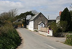
|picture caption=Former Methodist chapel at Laity Moor | |picture caption=Former Methodist chapel at Laity Moor | ||
| − | + | |os grid ref=SW758367 | |
|latitude=50.188 | |latitude=50.188 | ||
|longitude=-5.142 | |longitude=-5.142 | ||
| Line 12: | Line 12: | ||
|postcode= | |postcode= | ||
|dialling code= | |dialling code= | ||
| − | |LG district= | + | |LG district=Cornwall |
}} | }} | ||
'''Laity Moor''' is a tiny hamlet in [[Cornwall]], of cottages strung loosely along a lane south of [[Ponsanooth]] , two miles north-west of [[Penryn]] and three from [[Falmouth]]. | '''Laity Moor''' is a tiny hamlet in [[Cornwall]], of cottages strung loosely along a lane south of [[Ponsanooth]] , two miles north-west of [[Penryn]] and three from [[Falmouth]]. | ||
Latest revision as of 22:52, 12 August 2016
| Laity Moor | |
| Cornwall | |
|---|---|
 Former Methodist chapel at Laity Moor | |
| Location | |
| Grid reference: | SW758367 |
| Location: | 50°11’17"N, 5°8’31"W |
| Data | |
| Local Government | |
| Council: | Cornwall |
Laity Moor is a tiny hamlet in Cornwall, of cottages strung loosely along a lane south of Ponsanooth , two miles north-west of Penryn and three from Falmouth.
The name of the village is likely to be related to the Laity family who come from there.