Kirkpatrick Durham
From Wikishire
Revision as of 20:29, 14 April 2015 by RB (Talk | contribs) (Created page with "{{Infobox town |name=Kirkpatrick Durham |county=Kirkcudbrightshire |picture=Kirk, Kirkpatrick Durham - geograph.org.uk - 71316.jpg |picture caption=The parish kirk, Kirkpatric...")
| Kirkpatrick Durham | |
| Kirkcudbrightshire | |
|---|---|
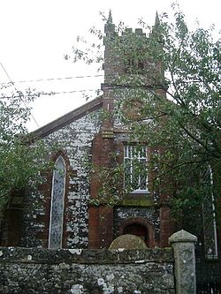
 The parish kirk, Kirkpatrick Durham | |
| Location | |
| Location: | 55°-0’32"N, 3°54’5"W |
| Data | |
| Local Government | |
| Council: | Dumfries and Galloway |
Kirkpatrick Durham is a village and parish in Kirkcudbrightshire, sitting six miles north of Castle Douglas. The village was developed in the late 18th century as a handloom weaving centre, within the existing parish of the same name. The present church was built in 1850 by Dumfries-based architect Walter Newall.[1]
Outside links
| ("Wikimedia Commons" has material about Kirkpatrick Durham) |
References
- ↑ Colvin, Howard, (1978) A Biographical Dictionary of British Architects, 1600–1840, John Murray, pp.697-699
- Kirkpatrick Durham - Gazetteer for Scotland
- Robert Burns and Kirkpatrick Durham
