Difference between revisions of "Holywell Lake"
From Wikishire
(Created page with '{{Infobox town |name=Holywell Lake |county=Somerset |picture= |os grid ref=ST104202 |latitude=50.974547 |longitude=-3.276284 |population= |census year= |post town= |postcode=TA21…') |
m |
||
| Line 2: | Line 2: | ||
|name=Holywell Lake | |name=Holywell Lake | ||
|county=Somerset | |county=Somerset | ||
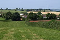
| − | |picture= | + | |picture=Approaching Holywell Lake - geograph.org.uk - 1347383.jpg |
|os grid ref=ST104202 | |os grid ref=ST104202 | ||
|latitude=50.974547 | |latitude=50.974547 | ||
Latest revision as of 21:47, 9 November 2012
| Holywell Lake | |
| Somerset | |
|---|---|

| |
| Location | |
| Grid reference: | ST104202 |
| Location: | 50°58’28"N, 3°16’35"W |
| Data | |
| Postcode: | TA21 |
| Local Government | |
| Council: | South Somerset |
Holywell Lake is a tiny village in Somerset, on a stream which soon runs down to feed the nearby River Tone. The village is just west of Wellington and a step north of the A38 trunk road out of Taunton.
The village is named after the ancient well here, one of the many reputed a holy well in the Middle Ages.
Holywell Lake is one of the Thankful Villages; those few places which suffered no casualties amongst their men in the First World War.
This Somerset article is a stub: help to improve Wikishire by building it up.