Hamsey
| Hamsey | |
| Sussex | |
|---|---|
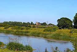
 St Peter's Church, Hamsey | |
| Location | |
| Grid reference: | TQ409128 |
| Location: | 50°53’54"N, 0°0’10"E |
| Data | |
| Population: | 632 (2011) |
| Post town: | Lewes |
| Postcode: | BN7, BN8 |
| Dialling code: | 01273 |
| Local Government | |
| Council: | Lewes |
| Parliamentary constituency: |
Lewes |
| Website: | http://www.hamsey.net/ |
Hamsey is a village in Sussex, in the south of the county, three miles north of Lewes, with the Greenwich Meridian running through it. This is a place of scattered hamlets, with Offham to the west and Cooksbridge north-west (and all within the same civil parish, named after Hamsey.
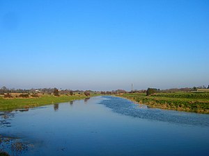
The village is on lanes off the A275 road to Lewes (which runs to the west) and spreads down to the tidal reach of the River Ouse.
The fine mediæval ex-parish Church, Old St Peter's (now a Chapel of Ease) stands on an island formed between a wider meander of the river and the Hamsey Cut (part of the old Ouse Navigation).
The fine old barns of the prosperous farmstead of Hamsey Place have been converted to a number of dwellings, and a large new pond created, with geese. From here there is a lane that ends with Old St Peter's church. There is a group of fairly large houses on the edge of the floodplain to the north-west, including the large country house Hamsey House.
To the south of the parish, the land rises into the Sussex Downs. It is last parish (or first) of the Clayton to Offham Escarpment which is a six-mile stretch of north-facing scarp that has been designed a Site of Special Scientific Interest.
Rivers and stream
Running along the eastern boundary of the county is the River Ouse. The river was used extensively in the 19th century to import chalk from the Offham Chalk pits. The Upper Ouse Navigation was opened in 1812 and the Chalkpit Cut took barges from Offham chalk pit to the river, and two railway lines were built across the brooks. Up until that point wild salmon and sea trout were plentiful in the river but the canalisation seems to have impacted the young Salmons' ability to use the river. After the collapse of the navigation in 1870 Salmon recolonised the Ouse until the hot summer of 1976 and the new weir at Buxted eliminated the last breeding group.[1]
Hamsey brickworks
Often considered to be in South Chailey, Hamsey Brickworks, is in the very north of the parish. It worked the Wealden clay to make bricks until the late 1980s. After working ceased an almost complete fossil of a bony fish was found there, which 130 million years old.[2]
The landfilled quarry has a large pond which is home to tufted duck and great crested grebe, with many mayflies in summer dancing above it - and feeding the swallows that skim the water to eat them. To the south of the pond, "flaming gorse" separates the brickworks from Kiln Wood. Recently the area has been approved for redevelopment into housing,
Outside links
| ("Wikimedia Commons" has material about Hamsey) |
References
- ↑ Ouse Angling Preservation Society Newsletter, 2012-13 season. Dave Brown.
- ↑ Flannery Sutherland, Joseph T.; Austen, Peter A.; Duffin, Christopher J.; Benton, Michael J. (2017). "Leptolepid otoliths from the Hauterivian (Lower Cretaceous) Lower Weald Clay (southern England)" (in en). Proceedings of the Geologists' Association 128 (4): 613–625. doi:10.1016/j.pgeola.2017.05.001. https://linkinghub.elsevier.com/retrieve/pii/S0016787817300639.
