Difference between revisions of "Glenluce"
(→Villages and places in Old Luce) |
|||
| (3 intermediate revisions by 2 users not shown) | |||
| Line 29: | Line 29: | ||
==Castle of Park== | ==Castle of Park== | ||
| − | The Castle of Park is a 16th century L-plan tower house near Glenluce in Wigtownshire. The last Abbot of Glenluce Abbey gave the lands of Park to his son, Thomas Hay, and in 1590 he built the Tower House. | + | The Castle of Park is a 16th-century L-plan tower house near Glenluce in Wigtownshire. The last Abbot of Glenluce Abbey gave the lands of Park to his son, Thomas Hay, and in 1590 he built the Tower House. |
It was repaired by Historic Scotland and now leased to the Landmark Trust. | It was repaired by Historic Scotland and now leased to the Landmark Trust. | ||
| Line 36: | Line 36: | ||
'''Old Luce''' is the name of the parish of which Glenluce is the main village. The parish is around 10 miles long and 8 miles broad, and contains 40,350 acres.<ref>http://www.scottish-places.info/parishes/parmap1063.html</ref> | '''Old Luce''' is the name of the parish of which Glenluce is the main village. The parish is around 10 miles long and 8 miles broad, and contains 40,350 acres.<ref>http://www.scottish-places.info/parishes/parmap1063.html</ref> | ||
| − | The parish was anciently named | + | The parish was anciently named Glenluce, though this was divided in 1646 into two parts, the northern part named [[New Luce]], and the southern part named Old Luce.<ref>Caledonia Vol.III by George Chalmers, London, printed 1824., pp.441-442 http://archive.org/stream/caledoniaoraccou03chal#page/441/mode/1up</ref> |
<ref>Robert Chambers, William Chambers, The gazetteer of Scotland, Vol. II, Edinburgh, 1844, p. 500 & p.749, http://archive.org/stream/gazetteerofscov21838cham#page/n7/mode/2up</ref> In 1661 the two parishes of Old and New Luce were reunited for a time, and when the 1684 Wigtownshire Parish List was recorded, it listed both Old Luce and New Luce under "Glenluce Parish".<ref>http://archive.org/stream/parishlistsofwig72scot#page/10/mode/2up</ref> In 1688, after the Glorious Revolution, the separation of Old Luce and [[New Luce]] became permanent. | <ref>Robert Chambers, William Chambers, The gazetteer of Scotland, Vol. II, Edinburgh, 1844, p. 500 & p.749, http://archive.org/stream/gazetteerofscov21838cham#page/n7/mode/2up</ref> In 1661 the two parishes of Old and New Luce were reunited for a time, and when the 1684 Wigtownshire Parish List was recorded, it listed both Old Luce and New Luce under "Glenluce Parish".<ref>http://archive.org/stream/parishlistsofwig72scot#page/10/mode/2up</ref> In 1688, after the Glorious Revolution, the separation of Old Luce and [[New Luce]] became permanent. | ||
| Line 42: | Line 42: | ||
==Villages and places in Old Luce== | ==Villages and places in Old Luce== | ||
| − | The town of | + | The town of Glenluce and Glenluce Church are in Old Luce Parish, as is [[Glenluce Abbey]]. |
| − | In 1846 in the Topographical Dictionary of Scotland, Samuel Lewis wrote of that the village of | + | In 1846 in the Topographical Dictionary of Scotland, Samuel Lewis wrote of that the village of Glenluce: |
"The church, erected in 1814, is a commodious edifice, and situated close to the village. The members of the United Secession have a place of worship. There are several other schools, of which two are connected with dissenters, and one is supported by the Hay family."<ref>A Topographical Dictionary of Scotland, by Samuel Lewis. 1846</ref> | "The church, erected in 1814, is a commodious edifice, and situated close to the village. The members of the United Secession have a place of worship. There are several other schools, of which two are connected with dissenters, and one is supported by the Hay family."<ref>A Topographical Dictionary of Scotland, by Samuel Lewis. 1846</ref> | ||
| Line 52: | Line 52: | ||
There is a possible Roman cremation cemetery and two castle mottes in the village. | There is a possible Roman cremation cemetery and two castle mottes in the village. | ||
| − | The deposed King of Dublin and Man, | + | The deposed King of Dublin and Man, Echmarcach mac Ragnaill (Ragnallsson), had the title ''Rex Innarenn'' ("King of the Rhinns") attributed to him on his death in 1065. The western sections of [[Galloway]] had been firmly aligned with the [[Isle of Man]], and Norse and Gaelic-Norse settlement names from the 10th and 11th centuries are spread all along the coastal lands of [[Galloway]] and [[Dumfriesshire]]. |
Glenwhan Garden, has been created in [[Dunragit]] since 1979, and today is open to the public. | Glenwhan Garden, has been created in [[Dunragit]] since 1979, and today is open to the public. | ||
| − | [[Carscreugh Castle]] (of Earl of Stair in 1782) was the home of Janet Dalrymple, on whom Sir Walter Scott based his heroine Lucy, the Bride of Lammermoor, (who became Lucia di Lammermoor in Donizetti's opera of the same name.) Janet fell in love with and secretly betrothed to a penniless local man, Archibald Rutherford. Her parents bitterly opposed this liaison and forced her to renounce her vow and marry another man from a wealthy local family, Sir David Dunbar of Baldoon Castle near Wigtown. However something dreadful happened on her wedding night which ended in her death and the wounding of her husband, who ever afterwards refused to divulge to anyone what had occurred that night. | + | [[Carscreugh Castle]] (of Earl of Stair in 1782) was the home of Janet Dalrymple, on whom Sir Walter Scott based his heroine Lucy, the Bride of Lammermoor, (who became Lucia di Lammermoor in Donizetti's opera of the same name.) Janet fell in love with and secretly betrothed to a penniless local man, Archibald Rutherford. Her parents bitterly opposed this liaison and forced her to renounce her vow and marry another man from a wealthy local family, Sir David Dunbar of Baldoon Castle near Wigtown. However something dreadful happened on her wedding night which ended in her death and the wounding of her husband, who ever afterwards refused to divulge to anyone what had occurred that night. |
==Archaeology== | ==Archaeology== | ||
From Glenluce Sands there have been recovered "more objects of antiquity than from any area of similar extent in Scotland". The relics range from neolithic to mediæval times.<ref>"Kirkcudbrightshire and Wigtownshire"</ref><ref>http://www.megalithic.co.uk/article.php?sid=25441</ref> | From Glenluce Sands there have been recovered "more objects of antiquity than from any area of similar extent in Scotland". The relics range from neolithic to mediæval times.<ref>"Kirkcudbrightshire and Wigtownshire"</ref><ref>http://www.megalithic.co.uk/article.php?sid=25441</ref> | ||
| − | St. John's Chapel at The Knock of Luce was at one time a chapel of St. John. The tenant, Mr. Wilson, told Rev. George Wilson that he removed three distinct paved floors, one above the other. This indicated a long occupation. <ref>http://archive.org/stream/churchdedicatio01mackuoft#page/280/mode/2up</ref> | + | St. John's Chapel at The Knock of Luce was at one time a chapel of St. John. The tenant, Mr. Wilson, told Rev. George Wilson that he removed three distinct paved floors, one above the other. This indicated a long occupation.<ref>http://archive.org/stream/churchdedicatio01mackuoft#page/280/mode/2up</ref> |
===Forts and brochs=== | ===Forts and brochs=== | ||
| Line 69: | Line 69: | ||
#Two at Glenwhan, Dunragit | #Two at Glenwhan, Dunragit | ||
#Two in a wood called Baraigle near Dunragit | #Two in a wood called Baraigle near Dunragit | ||
| − | #Roon Dounan, Dunragit House, north Dunragit Village <ref>http://canmore.rcahms.gov.uk/en/site/61250/details/round+dounan/</ref> A stone-built 5th-6th century fort of Rheged on a natural hillock of outcropping rock, | + | #Roon Dounan, Dunragit House, north Dunragit Village <ref>http://canmore.rcahms.gov.uk/en/site/61250/details/round+dounan/</ref> A stone-built 5th-6th century fort of Rheged on a natural hillock of outcropping rock, 12–14 ft high with an 18 ft terrace on the west side. |
#Two on Craig, each with a hut circle. (Perhaps Old Hall of Craig at Airyhemming) | #Two on Craig, each with a hut circle. (Perhaps Old Hall of Craig at Airyhemming) | ||
#Three forts at Airyhemming, one with a cup-shaped floor at one end.<ref>http://canmore.rcahms.gov.uk/en/site/61173/details/old+hall+of+craig+airyhemming/</ref> | #Three forts at Airyhemming, one with a cup-shaped floor at one end.<ref>http://canmore.rcahms.gov.uk/en/site/61173/details/old+hall+of+craig+airyhemming/</ref> | ||
#Stairhaven broch.<ref>http://www.megalithic.co.uk/article.php?sid=26005</ref> | #Stairhaven broch.<ref>http://www.megalithic.co.uk/article.php?sid=26005</ref> | ||
| − | #A fort 1/4 mile south of the pier shown on the O.S. map as a cairn. <ref>http://maps.nls.uk/os/6inch/view/?sid=74431142#sid=74431142&zoom=6&lat=7746&lon=14340&layers=BT</ref> | + | #A fort 1/4 mile south of the pier shown on the O.S. map as a cairn.<ref>http://maps.nls.uk/os/6inch/view/?sid=74431142#sid=74431142&zoom=6&lat=7746&lon=14340&layers=BT</ref> |
#Near Low Sunonness fort called Garliachen.<ref>http://canmore.rcahms.gov.uk/en/site/62239/details/garliachen+laigh+sinniness/</ref> | #Near Low Sunonness fort called Garliachen.<ref>http://canmore.rcahms.gov.uk/en/site/62239/details/garliachen+laigh+sinniness/</ref> | ||
#Ring on Mull of Sunonness. (perhaps Garliachen) | #Ring on Mull of Sunonness. (perhaps Garliachen) | ||
#On Barhaskine at the Carlinwark.<ref>The Carlinwark on Craignaget Fell http://canmore.rcahms.gov.uk/en/site/62224/details/craignarget+hill+the+carlinwark/</ref> | #On Barhaskine at the Carlinwark.<ref>The Carlinwark on Craignaget Fell http://canmore.rcahms.gov.uk/en/site/62224/details/craignarget+hill+the+carlinwark/</ref> | ||
| − | #Fortified town on Knock Hill. The Knock, Old Luce, or Knock of Luce or Knock Fell fort <ref>http://www.megalithic.co.uk/article.php?sid=10331</ref> This ancient fortified village stands on the highest hill in Old Luce and may have been built by the makers of the extensive lake dwellings in Machermore Loch about 2 miles to the west. There was an outer defence at the west end on a lower shelving slope. It had an entrance gap of about 10 feet at each end, that at the south-western end appeared to have heavy defences, but the whole fort was dilapidated to build a dry stone wall along the south-side of the Fell. There were traces of 6 or 7 hut circles along the line of fortification and outside on a small flat space on the steep northern side (click on photo below) there was a half-circle of about | + | #Fortified town on Knock Hill. The Knock, Old Luce, or Knock of Luce or Knock Fell fort <ref>http://www.megalithic.co.uk/article.php?sid=10331</ref> This ancient fortified village stands on the highest hill in Old Luce and may have been built by the makers of the extensive lake dwellings in Machermore Loch about 2 miles to the west. There was an outer defence at the west end on a lower shelving slope. It had an entrance gap of about 10 feet at each end, that at the south-western end appeared to have heavy defences, but the whole fort was dilapidated to build a dry stone wall along the south-side of the Fell. There were traces of 6 or 7 hut circles along the line of fortification and outside on a small flat space on the steep northern side (click on photo below) there was a half-circle of about 20 ft in diameter. Down the western-slope there was a cluster of small cairns, and a cluster of green hut circles.<ref>Antiquities of Glenluce. Rev. George Wilson. 1899</ref> |
#Ring on Barnsallzie moor. Barnsallie Hut Circle <ref>http://canmore.rcahms.gov.uk/en/site/62171/details/barnsallie+fell/</ref> | #Ring on Barnsallzie moor. Barnsallie Hut Circle <ref>http://canmore.rcahms.gov.uk/en/site/62171/details/barnsallie+fell/</ref> | ||
| − | #Circular fort at Drumearnachan (at Barlea or Barfad, Kirkcowan), not on O.S. map, but detailed on p.56, vol.III. <ref>Archaeological and Historical Collections relating to Ayrshire and Galloway. vol.III p.56 http://www26.us.archive.org/stream/cu31924092901580#page/n93/mode/2up</ref> | + | #Circular fort at Drumearnachan (at Barlea or Barfad, Kirkcowan), not on O.S. map, but detailed on p. 56, vol.III.<ref>Archaeological and Historical Collections relating to Ayrshire and Galloway. vol.III p.56 http://www26.us.archive.org/stream/cu31924092901580#page/n93/mode/2up</ref> |
#Mouth of River Piltanton Corrylinn or Corachlinn. | #Mouth of River Piltanton Corrylinn or Corachlinn. | ||
#High Torrs called Knockdoon. | #High Torrs called Knockdoon. | ||
| − | Droughdool Mote or Mound, south Dunragit Village, has a base of | + | Droughdool Mote or Mound, south Dunragit Village, has a base of 156 ft diameter, is 30 ft high with a level top of 40 ft diameter.<ref>http://canmore.rcahms.gov.uk/en/site/61278/details/droughdool+mote/</ref> |
Dunragit henge between the Mound and Dunragit village is one of the most important Stone Age sites in the north. It is a pit defined cursus monument, dating from Neolithic and Bronze Age times. It was first discovered by aerial photography in 1992. Dunragit Excavations Project Archaeological excavation has revealed the remains of three massive concentric timber circles; the outer circle was 350 yards diameter; almost six times the size of [[Stonehenge]], and that it was built around 2500 BC.<ref>Dunragit Cursus Excavations http://orgs.man.ac.uk/research/dunragit/ Dunragit Cursus Excavations</ref><ref>http://orgs.man.ac.uk/research/dunragit/</ref> | Dunragit henge between the Mound and Dunragit village is one of the most important Stone Age sites in the north. It is a pit defined cursus monument, dating from Neolithic and Bronze Age times. It was first discovered by aerial photography in 1992. Dunragit Excavations Project Archaeological excavation has revealed the remains of three massive concentric timber circles; the outer circle was 350 yards diameter; almost six times the size of [[Stonehenge]], and that it was built around 2500 BC.<ref>Dunragit Cursus Excavations http://orgs.man.ac.uk/research/dunragit/ Dunragit Cursus Excavations</ref><ref>http://orgs.man.ac.uk/research/dunragit/</ref> | ||
| Line 104: | Line 104: | ||
File:Knock of Luce from Mull of Sinniness - geograph.org.uk - 445842.jpg|Knock of Luce (Knock Fell), view of Fort location from Mull of Sinniness | File:Knock of Luce from Mull of Sinniness - geograph.org.uk - 445842.jpg|Knock of Luce (Knock Fell), view of Fort location from Mull of Sinniness | ||
File:Wild rose, Knock of Luce - geograph.org.uk - 870071.jpg|Knock of Luce ancient village fort. Rock face on steep northern slope | File:Wild rose, Knock of Luce - geograph.org.uk - 870071.jpg|Knock of Luce ancient village fort. Rock face on steep northern slope | ||
| − | |||
File:Stairhaven broch - intramural stairs - geograph.org.uk - 590703.jpg|Stairhaven Iron-age broch - intramural stairs | File:Stairhaven broch - intramural stairs - geograph.org.uk - 590703.jpg|Stairhaven Iron-age broch - intramural stairs | ||
| − | |||
File:Black Cairn, Old Luce, Wigtownshire.jpg|Black Cairn | File:Black Cairn, Old Luce, Wigtownshire.jpg|Black Cairn | ||
File:High Gillespie chambered cairn - geograph.org.uk - 727131.jpg|High Gillespie chambered cairn | File:High Gillespie chambered cairn - geograph.org.uk - 727131.jpg|High Gillespie chambered cairn | ||
Latest revision as of 11:36, 1 October 2017
| Glenluce | |
| Wigtownshire | |
|---|---|
 Main Street, Glenluce | |
| Location | |
| Grid reference: | NX197573 |
| Location: | 54°52’41"N, 4°48’40"W |
| Data | |
| Post town: | Newton Stewart |
| Postcode: | DG8 |
| Dialling code: | 01581 |
| Local Government | |
| Council: | Dumfries and Galloway |
| Parliamentary constituency: |
Dumfries and Galloway |
Glenluce is a village in the Parish of Old Luce in Wigtownshire. It is to be found on the A75 road between Stranraer and Newton Stewart.
Glenluce (Old Luce) has a Community Council.[1]
Its main centre runs along the main street, which until recently was relatively busy until the bypass was built.
There is a general store, two hotels, two caravan parks and a town hall.
Each year around September, there is a vehicle show in the nearby Park of Glenluce Park where people show off anything from vintage tractors to the most recent cars.
Contents
The Church
The Parish Church of Glenluce, with the two chapels, were vested in the king by the Act of 1587.[2][3][4] The church is now in the parish area called Old Luce, Wigtownshire [5]
In 1646 the parish area of Glenluce was divided into two sections, the area to the south called Old Luce, and the area to the north called New Luce.[6]
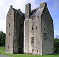
Castle of Park
The Castle of Park is a 16th-century L-plan tower house near Glenluce in Wigtownshire. The last Abbot of Glenluce Abbey gave the lands of Park to his son, Thomas Hay, and in 1590 he built the Tower House.
It was repaired by Historic Scotland and now leased to the Landmark Trust.
Old Luce
Old Luce is the name of the parish of which Glenluce is the main village. The parish is around 10 miles long and 8 miles broad, and contains 40,350 acres.[7]
The parish was anciently named Glenluce, though this was divided in 1646 into two parts, the northern part named New Luce, and the southern part named Old Luce.[8] [9] In 1661 the two parishes of Old and New Luce were reunited for a time, and when the 1684 Wigtownshire Parish List was recorded, it listed both Old Luce and New Luce under "Glenluce Parish".[10] In 1688, after the Glorious Revolution, the separation of Old Luce and New Luce became permanent.
Old Luce has a Community Council.[11]
Villages and places in Old Luce
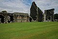
The town of Glenluce and Glenluce Church are in Old Luce Parish, as is Glenluce Abbey.
In 1846 in the Topographical Dictionary of Scotland, Samuel Lewis wrote of that the village of Glenluce:
"The church, erected in 1814, is a commodious edifice, and situated close to the village. The members of the United Secession have a place of worship. There are several other schools, of which two are connected with dissenters, and one is supported by the Hay family."[12]
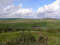
Dunragit is a village on the A75, between Stranraer and Glenluce in Old Luce. The place-name has been said to derive from Din Rheged meaning Fort of Rheged, which would refer to the Dark Age kingdom of Rheged that seems to have existed somewhere in this area and eastward to the Lake District between the 5th and 8th centuries. Severl poems in the Old Welsh language spoken in Rheged praise its King Urien. It is possible that Dunragit was one of the royal sites used by the kings of Rheged and it has been suggested as the site of the unidentified Northern Royal court Penrhyn Rhionedd, recorded in the Welsh Triads.
There is a possible Roman cremation cemetery and two castle mottes in the village.
The deposed King of Dublin and Man, Echmarcach mac Ragnaill (Ragnallsson), had the title Rex Innarenn ("King of the Rhinns") attributed to him on his death in 1065. The western sections of Galloway had been firmly aligned with the Isle of Man, and Norse and Gaelic-Norse settlement names from the 10th and 11th centuries are spread all along the coastal lands of Galloway and Dumfriesshire.
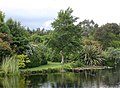
Glenwhan Garden, has been created in Dunragit since 1979, and today is open to the public.
Carscreugh Castle (of Earl of Stair in 1782) was the home of Janet Dalrymple, on whom Sir Walter Scott based his heroine Lucy, the Bride of Lammermoor, (who became Lucia di Lammermoor in Donizetti's opera of the same name.) Janet fell in love with and secretly betrothed to a penniless local man, Archibald Rutherford. Her parents bitterly opposed this liaison and forced her to renounce her vow and marry another man from a wealthy local family, Sir David Dunbar of Baldoon Castle near Wigtown. However something dreadful happened on her wedding night which ended in her death and the wounding of her husband, who ever afterwards refused to divulge to anyone what had occurred that night.
Archaeology
From Glenluce Sands there have been recovered "more objects of antiquity than from any area of similar extent in Scotland". The relics range from neolithic to mediæval times.[13][14]
St. John's Chapel at The Knock of Luce was at one time a chapel of St. John. The tenant, Mr. Wilson, told Rev. George Wilson that he removed three distinct paved floors, one above the other. This indicated a long occupation.[15]
Forts and brochs
Rev. George Wilson, in his Archaeological and Historical Collections relating to Ayrshire and Galloway, relates that Wigtownshire contains about sixty forts; 15 in Mochrum, 4 in Glasserton, 10 in Whithorn, and several more in the other parishes not named in his list. He lists the following forts in Old Luce:[16][17]
- Three at Glenhinnie or Glenhinney hut circles, Dunragit Moor [18]
- Two at Glenwhan, Dunragit
- Two in a wood called Baraigle near Dunragit
- Roon Dounan, Dunragit House, north Dunragit Village [19] A stone-built 5th-6th century fort of Rheged on a natural hillock of outcropping rock, 12–14 ft high with an 18 ft terrace on the west side.
- Two on Craig, each with a hut circle. (Perhaps Old Hall of Craig at Airyhemming)
- Three forts at Airyhemming, one with a cup-shaped floor at one end.[20]
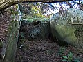
- Stairhaven broch.[21]
- A fort 1/4 mile south of the pier shown on the O.S. map as a cairn.[22]
- Near Low Sunonness fort called Garliachen.[23]
- Ring on Mull of Sunonness. (perhaps Garliachen)
- On Barhaskine at the Carlinwark.[24]
- Fortified town on Knock Hill. The Knock, Old Luce, or Knock of Luce or Knock Fell fort [25] This ancient fortified village stands on the highest hill in Old Luce and may have been built by the makers of the extensive lake dwellings in Machermore Loch about 2 miles to the west. There was an outer defence at the west end on a lower shelving slope. It had an entrance gap of about 10 feet at each end, that at the south-western end appeared to have heavy defences, but the whole fort was dilapidated to build a dry stone wall along the south-side of the Fell. There were traces of 6 or 7 hut circles along the line of fortification and outside on a small flat space on the steep northern side (click on photo below) there was a half-circle of about 20 ft in diameter. Down the western-slope there was a cluster of small cairns, and a cluster of green hut circles.[26]
- Ring on Barnsallzie moor. Barnsallie Hut Circle [27]
- Circular fort at Drumearnachan (at Barlea or Barfad, Kirkcowan), not on O.S. map, but detailed on p. 56, vol.III.[28]
- Mouth of River Piltanton Corrylinn or Corachlinn.
- High Torrs called Knockdoon.
Droughdool Mote or Mound, south Dunragit Village, has a base of 156 ft diameter, is 30 ft high with a level top of 40 ft diameter.[29]
Dunragit henge between the Mound and Dunragit village is one of the most important Stone Age sites in the north. It is a pit defined cursus monument, dating from Neolithic and Bronze Age times. It was first discovered by aerial photography in 1992. Dunragit Excavations Project Archaeological excavation has revealed the remains of three massive concentric timber circles; the outer circle was 350 yards diameter; almost six times the size of Stonehenge, and that it was built around 2500 BC.[30][31]
Crannogs
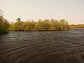
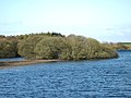
Whitefield Loch has two crannogs: Dormans Island crannog of 250 BC; and Tree Island crannog. The latter is now on dry land due to the fallen water level in the Loch.[32] Whitefield is near Machermore, ancient castle of the MacDowall Clan.
Pictures
Glenluce
Castle of Park, Glenluce
Glenluce Abbey


Wider Old Luce
Carscreugh Castle
Milton Bridge near site of Kirkchrist chapel and well
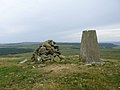
Knock Fell trig (Knock Hill Fort)
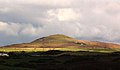
Knock of Luce (Knock Fell), view of Fort location from Mull of Sinniness
Knock of Luce ancient village fort. Rock face on steep northern slope
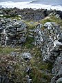
Stairhaven Iron-age broch - intramural stairs
Black Cairn
High Gillespie chambered cairn
Garliachen Fort, Laigh Sinniness, Old Luce
near 3 forts at Airyhemming (Arehemen)
possibly Tree Island Crannog, Whitefield Loch - Machermore Loch
Dorman's Island Crannog, Whitefield Loch - Machermore Loch
Machermore, Barony Glenluce, of Clan Macdowall
Glenwhan Garden in Dunragit
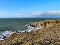
Ringadoo Point near Dunragit


See also
Outside links
| ("Wikimedia Commons" has material about Glenluce) |
| ("Wikimedia Commons" has material about Old Luce) |
References
- ↑ http://www.glenluce-online.org.uk/old_luce_community_council.html
- ↑ "Caledonia" Vol.III by George Chalmers, London, printed 1824., p.441
- ↑ National Records of Scotland. GALLOVIDIAE Pars Occidentalior, in qua VICECOMITATUS VICTONIENSIS cum Regalitate Glenlucensi
- ↑ Parish Lists of Wigtownshire. AD1684 p.10 http://archive.org/stream/parishlistsofwig72scot#page/10/mode/2up
- ↑ Robert Chambers, William Chambers, The gazetteer of Scotland, Vol. II, Edinburgh, 1844, p. 500 & p.749, http://archive.org/stream/gazetteerofscov21838cham#page/n7/mode/2up
- ↑ A Topographical Dictionary of Scotland, by Samuel Lewis. 1846
- ↑ http://www.scottish-places.info/parishes/parmap1063.html
- ↑ Caledonia Vol.III by George Chalmers, London, printed 1824., pp.441-442 http://archive.org/stream/caledoniaoraccou03chal#page/441/mode/1up
- ↑ Robert Chambers, William Chambers, The gazetteer of Scotland, Vol. II, Edinburgh, 1844, p. 500 & p.749, http://archive.org/stream/gazetteerofscov21838cham#page/n7/mode/2up
- ↑ http://archive.org/stream/parishlistsofwig72scot#page/10/mode/2up
- ↑ Glenluce Community Council
- ↑ A Topographical Dictionary of Scotland, by Samuel Lewis. 1846
- ↑ "Kirkcudbrightshire and Wigtownshire"
- ↑ http://www.megalithic.co.uk/article.php?sid=25441
- ↑ http://archive.org/stream/churchdedicatio01mackuoft#page/280/mode/2up
- ↑ Archaeological and Historical Collections relating to Ayrshire and Galloway. vol.V. pp.62-73 http://archive.org/stream/cu31924092901606#page/n115/mode/2up
- ↑ Archaeological and Historical Collections relating to Ayrshire and Galloway. vol.III p.56 http://www26.us.archive.org/stream/cu31924092901580#page/n93/mode/2up
- ↑ http://canmore.rcahms.gov.uk/en/site/61289/details/dunragit+moor/
- ↑ http://canmore.rcahms.gov.uk/en/site/61250/details/round+dounan/
- ↑ http://canmore.rcahms.gov.uk/en/site/61173/details/old+hall+of+craig+airyhemming/
- ↑ http://www.megalithic.co.uk/article.php?sid=26005
- ↑ http://maps.nls.uk/os/6inch/view/?sid=74431142#sid=74431142&zoom=6&lat=7746&lon=14340&layers=BT
- ↑ http://canmore.rcahms.gov.uk/en/site/62239/details/garliachen+laigh+sinniness/
- ↑ The Carlinwark on Craignaget Fell http://canmore.rcahms.gov.uk/en/site/62224/details/craignarget+hill+the+carlinwark/
- ↑ http://www.megalithic.co.uk/article.php?sid=10331
- ↑ Antiquities of Glenluce. Rev. George Wilson. 1899
- ↑ http://canmore.rcahms.gov.uk/en/site/62171/details/barnsallie+fell/
- ↑ Archaeological and Historical Collections relating to Ayrshire and Galloway. vol.III p.56 http://www26.us.archive.org/stream/cu31924092901580#page/n93/mode/2up
- ↑ http://canmore.rcahms.gov.uk/en/site/61278/details/droughdool+mote/
- ↑ Dunragit Cursus Excavations http://orgs.man.ac.uk/research/dunragit/ Dunragit Cursus Excavations
- ↑ http://orgs.man.ac.uk/research/dunragit/
- ↑ http://canmore.rcahms.gov.uk/en/site/62160/details/dorman+s+island+whitefield+loch/