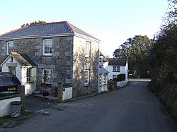
Garras
From Wikishire
Revision as of 22:39, 3 August 2016 by RB (Talk | contribs) (Created page with "{{Infobox town |name=Garras |cornish=Garros |county=Cornwall |picture=Approaching Garras crossroads - geograph.org.uk - 384961.jpg |picture caption=Garras |os grid ref=SW70223...")
| Garras Cornish: Garros | |
| Cornwall | |
|---|---|
 Garras | |
| Location | |
| Grid reference: | SW702239 |
| Location: | 50°4’17"N, 5°12’42"W |
| Data | |
| Postcode: | TR12 |
| Local Government | |
Garras is a village in the parish of Mawgan-in-Meneage, in western Cornwall. It is set at a crossroads on the B3293, half a mile south of Mawgan.