Difference between revisions of "Flood's Ferry"
From Wikishire
(Created page with '{{Infobox town |name=Flood's Ferry |county=Cambridgeshire |picture=Bridge at Flood's Ferry. - geograph.org.uk - 413971.jpg |picture caption=The bridge at Flood's Ferry |os grid r…') |
|||
| Line 9: | Line 9: | ||
|population= | |population= | ||
|census year= | |census year= | ||
| − | |post town= | + | |post town=March |
|postcode=PE15 | |postcode=PE15 | ||
| − | |dialling code= | + | |dialling code=01354 |
|LG district=Fenland | |LG district=Fenland | ||
|constituency= | |constituency= | ||
| Line 17: | Line 17: | ||
'''Flood's Ferry''' is a tiny [[Cambridgeshire]] hamlet, deep in the [[Great Fen]]. | '''Flood's Ferry''' is a tiny [[Cambridgeshire]] hamlet, deep in the [[Great Fen]]. | ||
| − | The hamlet sits where the [[Whittlesey Dike]] meets the [[River Nene]] on the edge of [[Ransom Moor]], at the bend in the long lane between [[March, Cambridgeshire]] to the east and [[Benwick]] to the south. There may be no ferry here now, but there is a farm track bridge over the Nene. | + | The hamlet sits where the [[Whittlesey Dike]] meets the [[River Nene]] on the edge of [[Ransom Moor]], at the bend in the long lane between [[March, Cambridgeshire|March]] to the east and [[Benwick]] to the south. There may be no ferry here now, but there is a farm track bridge over the Nene. |
Flood's Ferry is the site of a large marina on the old course of the [[River Nene]].<ref>[http://www.floodsferrymarina.co.uk/#/about/4556002329 Flood's Ferry Marina]</ref> | Flood's Ferry is the site of a large marina on the old course of the [[River Nene]].<ref>[http://www.floodsferrymarina.co.uk/#/about/4556002329 Flood's Ferry Marina]</ref> | ||
| − | |||
==References== | ==References== | ||
{{reflist}} | {{reflist}} | ||
| − | + | [[File:Bend by Flood's Ferry. - geograph.org.uk - 414011.jpg|left|thumb|200px|Flood's Ferry]] | |
| − | + | ||
| − | + | ||
{{stub}} | {{stub}} | ||
Latest revision as of 11:55, 20 November 2018
| Flood's Ferry | |
| Cambridgeshire | |
|---|---|
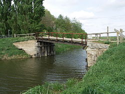
 The bridge at Flood's Ferry | |
| Location | |
| Grid reference: | TL356933 |
| Location: | 52°31’16"N, 0°0’7"W |
| Data | |
| Post town: | March |
| Postcode: | PE15 |
| Dialling code: | 01354 |
| Local Government | |
| Council: | Fenland |
Flood's Ferry is a tiny Cambridgeshire hamlet, deep in the Great Fen.
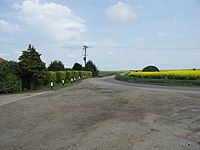
The hamlet sits where the Whittlesey Dike meets the River Nene on the edge of Ransom Moor, at the bend in the long lane between March to the east and Benwick to the south. There may be no ferry here now, but there is a farm track bridge over the Nene.
Flood's Ferry is the site of a large marina on the old course of the River Nene.[1]
