File:St Kenelm's Spring (Source of the River Stour) - geograph.org.uk - 806501.jpg
From Wikishire

Size of this preview: 450 × 600 pixels. Other resolution: 180 × 240 pixels.
Original file (480 × 640 pixels, file size: 366 KB, MIME type: image/jpeg)
_-_geograph.org.uk_-_806501.jpg)
Summary
| Description |
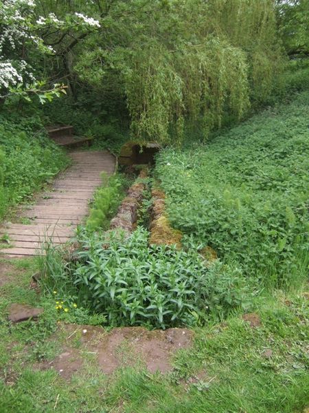
English: St Kenelm's Spring (Source of the River Stour) The spring is immediately below St Kenelm's Church on the slopes of the Clent Hills. The River Stour flows for 25 miles though the southern edge of the Black Country via Halesowen, Cradley, Lye, Stourbridge and Kidderminster to meet the River Severn at Stourport on Severn. The river was important in the beginning of the Industrial Revolution providing power for forges and mills. It is said that in the 17th century this was the most hard worked river in the country. |
| Date | |
| Source | From geograph.org.uk |
| Author | John M |
| Attribution (required by the license) | John M / St Kenelm's Spring (Source of the River Stour) / |
| Camera location | | View this and other nearby images on: OpenStreetMap |
|---|
_-_geograph.org.uk_-_806501.jpg¶ms=052.424570_N_-002.083000_E_globe:Earth_type:camera_source:geograph-osgb36(SO94458073)_heading:45.00&language=en)
| Object location | | View this and other nearby images on: OpenStreetMap |
|---|
_-_geograph.org.uk_-_806501.jpg¶ms=052.424840_N_-002.082400_E_globe:Earth_class:object_type:object_source:geograph-osgb36(SO94498076)_heading:45.00&language=en)
Licensing

|
This image was taken from the Geograph project collection. See this photograph's page on the Geograph website for the photographer's contact details. The copyright on this image is owned by John M and is licensed for reuse under the Creative Commons Attribution-ShareAlike 2.0 license.
|
This file is licensed under the Creative Commons Attribution-Share Alike 2.0 Generic license.
Attribution: John M
- You are free:
- to share – to copy, distribute and transmit the work
- to remix – to adapt the work
- Under the following conditions:
- attribution – You must give appropriate credit, provide a link to the license, and indicate if changes were made. You may do so in any reasonable manner, but not in any way that suggests the licensor endorses you or your use.
- share alike – If you remix, transform, or build upon the material, you must distribute your contributions under the same or compatible license as the original.
File history
Click on a date/time to view the file as it appeared at that time.
| Date/Time | Thumbnail | Dimensions | User | Comment | |
|---|---|---|---|---|---|
| current | 09:39, 20 February 2011 | | 480 × 640 (366 KB) | GeographBot | == {{int:filedesc}} == {{Information |description={{en|1=St Kenelm's Spring (Source of the River Stour) The spring is immediately below St Kenelm's Church on the slopes of the Clent Hills. The River Stour flows for 25 miles though the southern edge of the |
File usage
The following file is a duplicate of this file (more details):
_-_geograph.org.uk_-_806501.jpg)
- File:St Kenelm's Spring (Source of the River Stour) - geograph.org.uk - 806501.jpg from a shared repository
The following page links to this file:
_-_geograph.org.uk_-_806501.jpg)
_-_geograph.org.uk_-_806501.jpg)
_-_geograph.org.uk_-_806501.jpg&action=edit&redlink=1)
_-_geograph.org.uk_-_806501.jpg)
_-_geograph.org.uk_-_806501.jpg&action=info)