File:Point of Ayre lighthouse - geograph.org.uk - 1111783.jpg
From Wikishire
No higher resolution available.
Point_of_Ayre_lighthouse_-_geograph.org.uk_-_1111783.jpg (640 × 410 pixels, file size: 72 KB, MIME type: image/jpeg)
Summary
| Description |
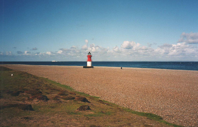
English: Point of Ayre lighthouse This lighthouse sits on the gravel spit at the most northerly point of the Isle of Man. Owing to the continuous accumulation of shingle deposited by the strong currents, this smaller light (referred to as a 'winkie') had to be built 750 feet to the seaward side of the main tower in 1899. It was then repositioned a further 250 feet in the same direction in 1950.
http://en.wikipedia.org/wiki/Point_of_Ayre |
| Date | |
| Source | From geograph.org.uk |
| Author | Trevor Rickard |
| Attribution (required by the license) | Trevor Rickard / Point of Ayre lighthouse / |
| Camera location | | View this and other nearby images on: OpenStreetMap |
|---|
_heading:0.00&language=en)
| Object location | | View this and other nearby images on: OpenStreetMap |
|---|
_heading:0.00&language=en)
Licensing

|
This image was taken from the Geograph project collection. See this photograph's page on the Geograph website for the photographer's contact details. The copyright on this image is owned by Trevor Rickard and is licensed for reuse under the Creative Commons Attribution-ShareAlike 2.0 license.
|
This file is licensed under the Creative Commons Attribution-Share Alike 2.0 Generic license.
Attribution: Trevor Rickard
- You are free:
- to share – to copy, distribute and transmit the work
- to remix – to adapt the work
- Under the following conditions:
- attribution – You must give appropriate credit, provide a link to the license, and indicate if changes were made. You may do so in any reasonable manner, but not in any way that suggests the licensor endorses you or your use.
- share alike – If you remix, transform, or build upon the material, you must distribute your contributions under the same or compatible license as the original.
File history
Click on a date/time to view the file as it appeared at that time.
| Date/Time | Thumbnail | Dimensions | User | Comment | |
|---|---|---|---|---|---|
| current | 21:57, 24 February 2011 | | 640 × 410 (72 KB) | GeographBot | == {{int:filedesc}} == {{Information |description={{en|1=Point of Ayre lighthouse This lighthouse sits on the gravel spit at the most northerly point of the Isle of Man. Owing to the continuous accumulation of shingle deposited by the strong currents, thi |
File usage
The following file is a duplicate of this file (more details):
- File:Point of Ayre lighthouse - geograph.org.uk - 1111783.jpg from a shared repository
The following 2 pages link to this file: