File:Mull of Oa, Islay aerial.jpg
From Wikishire

Size of this preview: 800 × 527 pixels. Other resolution: 320 × 211 pixels.
Original file (2,962 × 1,953 pixels, file size: 4.41 MB, MIME type: image/jpeg)
Summary
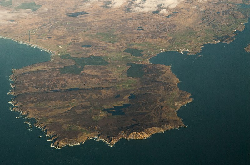
| Description | The Mull of Oa, on the south end of the island of Islay, Argyll, Scotland. The town on the right is Port Ellen. The high point above the cliffs is Bheinn Mhòr, at 201 meters. Islay Airport is at the top left. |
| Date | |
| Source | 2014_02_06_lhr-ewr_48z |
| Author | Doc Searls from Santa Barbara, USA |
Licensing
This file is licensed under the Creative Commons Attribution 2.0 Generic license.
- You are free:
- to share – to copy, distribute and transmit the work
- to remix – to adapt the work
- Under the following conditions:
- attribution – You must give appropriate credit, provide a link to the license, and indicate if changes were made. You may do so in any reasonable manner, but not in any way that suggests the licensor endorses you or your use.
| This image was originally posted to Flickr by dsearls at https://www.flickr.com/photos/52614599@N00/12355090515. It was reviewed on 26 March 2014 by FlickreviewR and was confirmed to be licensed under the terms of the cc-by-2.0. |
File history
Click on a date/time to view the file as it appeared at that time.
| Date/Time | Thumbnail | Dimensions | User | Comment | |
|---|---|---|---|---|---|
| current | 22:09, 25 March 2014 | | 2,962 × 1,953 (4.41 MB) | Tillman | Transferred from Flickr |
File usage
The following file is a duplicate of this file (more details):
- File:Mull of Oa, Islay aerial.jpg from a shared repository
The following page links to this file: