File:Moot Hall, Elstow - geograph.org.uk - 823252.jpg
Summary
| Description |
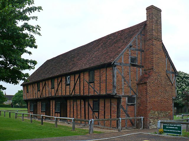
English: Moot Hall, Elstow An information board states:
Moot Hall is a timber framed building built in the late 15th century with red brick nogging and a clay roof. The upper floor is jettied on three sides supported by diagonal 'dragon beams' projecting at the two western corners. Originally it consisted of four bays but a further bay and external brick chimney were added to the eastern end in the late 16th century. Six shops once occupied the western part of the ground floor. The open upper hall running the full length of the building was originally used as a court and meeting room. In the 19th century the hall was used as a place of worship by non-conformists and as a school room. Moot Hall is now a museum containing both a collection of 16th and 17th century furniture and items relating to the life and works of John Bunyan who was born in Elstow parish and lived there for part of his life. http://www.discoverbedfordshire.co.uk/article.php?id=91&issueopen=2 |
| Date | |
| Source | From geograph.org.uk |
| Author | Robin Drayton |
| Attribution (required by the license) | Robin Drayton / Moot Hall, Elstow / |
| Camera location | | View this and other nearby images on: OpenStreetMap |
|---|
_heading:292.00&language=en)
| Object location | | View this and other nearby images on: OpenStreetMap |
|---|
_heading:292.00&language=en)
Licensing

|
This image was taken from the Geograph project collection. See this photograph's page on the Geograph website for the photographer's contact details. The copyright on this image is owned by Robin Drayton and is licensed for reuse under the Creative Commons Attribution-ShareAlike 2.0 license.
|
- You are free:
- to share – to copy, distribute and transmit the work
- to remix – to adapt the work
- Under the following conditions:
- attribution – You must give appropriate credit, provide a link to the license, and indicate if changes were made. You may do so in any reasonable manner, but not in any way that suggests the licensor endorses you or your use.
- share alike – If you remix, transform, or build upon the material, you must distribute your contributions under the same or compatible license as the original.
File history
Click on a date/time to view the file as it appeared at that time.
| Date/Time | Thumbnail | Dimensions | User | Comment | |
|---|---|---|---|---|---|
| current | 16:17, 20 February 2011 | | 640 × 480 (94 KB) | GeographBot | == {{int:filedesc}} == {{Information |description={{en|1=Moot Hall, Elstow An information board states: Moot Hall is a timber framed building constructed in the late 15th century with red brick infilling and a clay roof. The upper floor is jettied on th |
File usage
The following file is a duplicate of this file (more details):
- File:Moot Hall, Elstow - geograph.org.uk - 823252.jpg from a shared repository
The following 2 pages link to this file: