File:GlossopMap.svg
From Wikishire

Size of this preview: 549 × 599 pixels. Other resolution: 220 × 240 pixels.
Original file (SVG file, nominally 702 × 766 pixels, file size: 581 KB)
Summary
| Description |
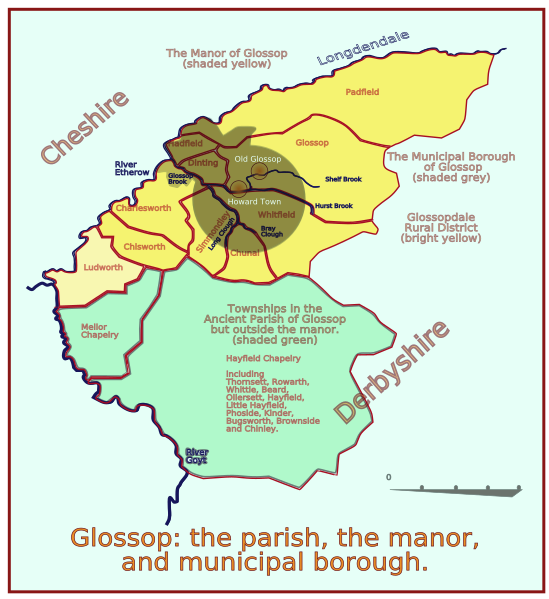
English: A map of Glossop in Derbyshire, showing how the name has been attached to differing areas in the last 900 years. The original hamlet or township is now called Old Glossop, and Howard Town is now called Glossop. The manor occupied half area of the parish, and only a small area of the manor became the municipal borough, though a few extra acres were added later. Note:The first upload did not render the text content. This was because svg:text is broken. Changed all to path- but two stubborn black boxed remainded -so I hid them behind a new background. This kludge appears to work. |
| Date | 6/7/2008 |
| Source | Own work |
| Author | ClemRutter |
| Other versions | Image:GlossopMapBit.png |
| Camera location | | View this and other nearby images on: OpenStreetMap |
|---|
Geotag refers to the centre of the municipal borough.
Licensing
I, the copyright holder of this work, hereby publish it under the following licenses:
This file is licensed under the Creative Commons Attribution-Share Alike 3.0 Unported license.
- You are free:
- to share – to copy, distribute and transmit the work
- to remix – to adapt the work
- Under the following conditions:
- attribution – You must give appropriate credit, provide a link to the license, and indicate if changes were made. You may do so in any reasonable manner, but not in any way that suggests the licensor endorses you or your use.
- share alike – If you remix, transform, or build upon the material, you must distribute your contributions under the same or compatible license as the original.

|
Permission is granted to copy, distribute and/or modify this document under the terms of the GNU Free Documentation License, Version 1.2 or any later version published by the Free Software Foundation; with no Invariant Sections, no Front-Cover Texts, and no Back-Cover Texts. A copy of the license is included in the section entitled GNU Free Documentation License. |
You may select the license of your choice.
File history
Click on a date/time to view the file as it appeared at that time.
| Date/Time | Thumbnail | Dimensions | User | Comment | |
|---|---|---|---|---|---|
| current | 18:13, 7 July 2008 | | 702 × 766 (581 KB) | ClemRutter | Repairing: text to path bug |
File usage
The following file is a duplicate of this file (more details):
- File:GlossopMap.svg from a shared repository
The following page links to this file: