File:EldonHole.JPG
From Wikishire

Size of this preview: 450 × 600 pixels. Other resolution: 180 × 240 pixels.
Original file (1,536 × 2,048 pixels, file size: 882 KB, MIME type: image/jpeg)
Summary
| Description |
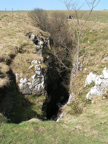
English: Eldon Hole. Deep pothole on the slopes of Eldon Hill near Castleton. According to the booklet Caves and Karst of the Peak District (BCRA Cave Studies Series Number 3): "The Hole forms a gaping chasm, 55m deep on the south flank of Eldon Hill. A tight, loose drop at the bottom leads into a large chamber and an 18th-century account suggests that there is a second drop in the floor to an underground river but it has long been concealed by boulders thrown down." See http://www.cressbrook.co.uk/visits/eldonhole.php for more information. |
| Date | 7 November 2007 (original upload date) |
| Source | Transferred from en.wikipedia to Commons by Dave.Dunford using CommonsHelper. |
| Author | Dave.Dunford at English Wikipedia |
| Other versions |
| Object location | | View this and other nearby images on: OpenStreetMap |
|---|
_&language=en)
Licensing
Dave.Dunford at English Wikipedia, the copyright holder of this work, hereby publishes it under the following licenses:

|
Permission is granted to copy, distribute and/or modify this document under the terms of the GNU Free Documentation License, Version 1.2 or any later version published by the Free Software Foundation; with no Invariant Sections, no Front-Cover Texts, and no Back-Cover Texts. A copy of the license is included in the section entitled GNU Free Documentation License. |
This file is licensed under the Creative Commons Attribution-Share Alike 3.0 Unported, 2.5 Generic, 2.0 Generic and 1.0 Generic license.
Attribution: Dave.Dunford at English Wikipedia
- You are free:
- to share – to copy, distribute and transmit the work
- to remix – to adapt the work
- Under the following conditions:
- attribution – You must give appropriate credit, provide a link to the license, and indicate if changes were made. You may do so in any reasonable manner, but not in any way that suggests the licensor endorses you or your use.
- share alike – If you remix, transform, or build upon the material, you must distribute your contributions under the same or compatible license as the original.
You may select the license of your choice.
Original upload log
The original description page was here. All following user names refer to en.wikipedia.
- 2007-11-07 16:06 Dave.Dunford 1536×2048× (902812 bytes)
File history
Click on a date/time to view the file as it appeared at that time.
| Date/Time | Thumbnail | Dimensions | User | Comment | |
|---|---|---|---|---|---|
| current | 11:46, 20 December 2010 | | 1,536 × 2,048 (882 KB) | File Upload Bot (Magnus Manske) | {{BotMoveToCommons|en.wikipedia|year={{subst:CURRENTYEAR}}|month={{subst:CURRENTMONTHNAME}}|day={{subst:CURRENTDAY}}}} {{Information |Description={{en|''no original description''}} |Source=Transferred from [http://en.wikipedia.org en.wikipedia]; transfer |
File usage
The following file is a duplicate of this file (more details):
- File:EldonHole.JPG from a shared repository
The following page links to this file: