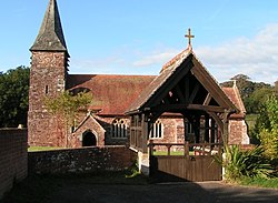
Farringdon, Devon
From Wikishire
Revision as of 18:02, 5 September 2018 by RB (Talk | contribs) (Created page with "{{Infobox town |name=Farringdon |county=Devon |picture=Farringdon Church - geograph.org.uk - 1516274.jpg |picture caption=St Petrock's Church, Farringdon |os grid ref=SY017911...")
| Farringdon | |
| Devon | |
|---|---|
 St Petrock's Church, Farringdon | |
| Location | |
| Grid reference: | SY017911 |
| Location: | 50°42’42"N, 3°23’35"W |
| Data | |
| Post town: | Exeter |
| Postcode: | EX5 |
| Local Government | |
| Council: | East Devon |
Farringdon is a village in eastern Devon, six miles east of Exeter city centre, alone on a loop of lane north of the Extere to Simouth road. The parish is surrounded clockwise from the north by the parishes of Clyst Honiton, Aylesbeare, a small part of Colaton Raleigh, Woodbury, Clyst St Mary and a small part of Sowton.[1]
Parish church
The parish church of St Petrock and St Barnabas[2] is a Grade II* listed building.[3] Rebuilt in 1870, it retains its original Norman font. One of its most famous incumbents was John Travers (died 1620), a Nottingham man who was brother to the famous puritan cleric Walter Travers and who was related by marriage to another, Richard Hooker.
Outside links
| ("Wikimedia Commons" has material about Farringdon, Devon) |
References
- ↑ "Map of Devon Parishes". Devon County Council. http://www.devon.gov.uk/devon_districts_2002_.pdf. Retrieved 20 June 2013.
- ↑ Farringdon: St Petrock and St Barnabas on A Church Near You
- ↑ National Heritage List 1328759: Church of St Petrock and St Barnabas