Difference between revisions of "Eilean Mòr, Enard Bay"
From Wikishire
(Created page with "{{Infobox island |name=Eilean Mòr |county=Cromartyshire |picture=Eilean Mòr - geograph.org.uk - 4567942.jpg |picture caption= |os grid ref=NC056173 |latitude=58.102654 |long...") |
|||
| Line 17: | Line 17: | ||
The island lies about 700 yards from the shore, off Loch an Èisg Brachaidh, four miles south-west of [[Lochinver]]. Its highest point is 177 feet above sea level. | The island lies about 700 yards from the shore, off Loch an Èisg Brachaidh, four miles south-west of [[Lochinver]]. Its highest point is 177 feet above sea level. | ||
| − | Just a quarter of a mile to the east lies [[Eilean | + | Just a quarter of a mile to the east lies [[Eilean Mòineseach]], while and [[Fraochlan]] is half a mile to the north-west of Eilean Mòr. |
==Outside links== | ==Outside links== | ||
{{commons}} | {{commons}} | ||
Latest revision as of 14:59, 25 February 2024
| Eilean Mòr | |

| |
|---|---|
| Location | |
| Location: | 58°6’10"N, 5°17’58"W |
| Grid reference: | NC056173 |
| Area: | 60 acres |
| Highest point: | 177 feet |
| Data | |
| Population: | Uninhabited |
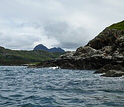
Eilean Mòr is the largest of a clutch of small, uninhabited islands in Enard Bay on the Atlantic coast of Cromartyshire.
The island lies about 700 yards from the shore, off Loch an Èisg Brachaidh, four miles south-west of Lochinver. Its highest point is 177 feet above sea level.
Just a quarter of a mile to the east lies Eilean Mòineseach, while and Fraochlan is half a mile to the north-west of Eilean Mòr.
Outside links
| ("Wikimedia Commons" has material about Eilean Mòr, Enard Bay) |