Difference between revisions of "Edithmead"
(Created page with "{{Infobox town |name=Edithmead |county=Somerset |picture=Homestead, Edithmead - geograph-3935132.jpg |picture caption=House in Edithmead |os grid ref=ST328491 |latitude=51.237...") |
|||
| Line 15: | Line 15: | ||
|constituency= | |constituency= | ||
}} | }} | ||
| − | '''Edithmead''' is a hamlet in the north of [[Somerset]], on the [[Somerset Levels]] a mile and a half inland of [[Burnham-on-Sea]] (to which town it is joined by the shot B3140 road). It is home to fewer than 200 souls. Its dwellings, mostly farms and cottages with a sprinkling of newer housing, cluster either side of the | + | '''Edithmead''' is a hamlet in the north of [[Somerset]], on the [[Somerset Levels]] a mile and a half inland of [[Burnham-on-Sea]] (to which town it is joined by the shot B3140 road). It is home to fewer than 200 souls. Its dwellings, mostly farms and cottages with a sprinkling of newer housing, cluster either side of the hamlet's single road. |
There is little to the hamlet but its farms and a small chapel, known as Edithmead Church, which is a chapel of ease to St Andrew's, Burnham-on-Sea.<ref>[http://standrewsbos.co.uk/buildings/edithmead-church.html St Andrew's, Burham-on-Sea - Edithmead]</ref> It is a small "tin chapel" built in 1919. | There is little to the hamlet but its farms and a small chapel, known as Edithmead Church, which is a chapel of ease to St Andrew's, Burnham-on-Sea.<ref>[http://standrewsbos.co.uk/buildings/edithmead-church.html St Andrew's, Burham-on-Sea - Edithmead]</ref> It is a small "tin chapel" built in 1919. | ||
Latest revision as of 19:25, 16 September 2018
| Edithmead | |
| Somerset | |
|---|---|
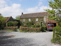
 House in Edithmead | |
| Location | |
| Grid reference: | ST328491 |
| Location: | 51°14’16"N, 2°57’45"W |
| Data | |
| Post town: | Highbridge |
| Postcode: | TA9 |
| Local Government | |
| Council: | Sedgemoor |
Edithmead is a hamlet in the north of Somerset, on the Somerset Levels a mile and a half inland of Burnham-on-Sea (to which town it is joined by the shot B3140 road). It is home to fewer than 200 souls. Its dwellings, mostly farms and cottages with a sprinkling of newer housing, cluster either side of the hamlet's single road.
There is little to the hamlet but its farms and a small chapel, known as Edithmead Church, which is a chapel of ease to St Andrew's, Burnham-on-Sea.[1] It is a small "tin chapel" built in 1919.
It has been said that the village derives its name from Queen Edith, wife of Edward the Confessor, and there is evidence that this lady did have estates in Somerset, though there is no supporting evidence otherwise.
History
An earthwork in the hamlet, described as a "moated site" is a scheduled historic monument.[2]
In 1841 the main Great Western Railway line from Paddington to Penzance was built through the northern pastures and gave birth to the two deep ponds and their teeming wildlife which have always been such a feature of the village.
In 1919, the village church was built – the little tin-clad mission church of St Andrew. Before the new Missioj hurch was consecrated church services had been held in a railway carriage. This railway carriage was stood in the doctor's garden and the particular plot where it stood was called Chapel Ground, and was very stony and hard to dig.
After hundreds of years of tranquillity and obscurity, Edithmead suddenly achieved a dubious kind of fame by becoming one of the many interchanges on the M5 motorway. The coming of the motorway, in addition to taking many acres of farmland to the south, occasioned a wide slip road to Burnham-on-Sea being built across pastures in the centre of the village, intersecting the original road, and completely changing the little hamlet.
References
- ↑ St Andrew's, Burham-on-Sea - Edithmead
- ↑ National Heritage List 1006134: Moated site, Edithmead
- Somerset Federation of Women's Institutes: 'The Somerset Village Book' (Countryside Books.[1]
