Darlingscott
From Wikishire
Revision as of 16:55, 3 February 2017 by Owain (Talk | contribs) (Created page with "{{infobox town |county 1=Worcester |county 2=Warwick |picture=Darlingscott - geograph.org.uk - 92504.jpg |picture caption=Darlingscott House and Lower Farmhouse |latitude=52.0...")
| Darlingscott | |
| Worcestershire, Warwickshire | |
|---|---|
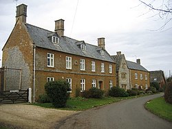
 Darlingscott House and Lower Farmhouse | |
| Location | |
| Grid reference: | SP2343 |
| Location: | 52°4’38"N, 1°39’42"W |
| Data | |
| Post town: | Shipston-on-Stour |
| Postcode: | CV35 |
| Dialling code: | 01608 |
| Local Government | |
| Council: | Stratford-on-Avon |
| Parliamentary constituency: |
Stratford-on-Avon |
Darlingscott is a small settlement in a detached part of Worcestershire, locally situate in Warwickshire. It is two miles north-west of Shipston-on-Stour in the same detached part, and two miles south-east of Ilmington in Warwickshire proper. The Fosse Way (also the A429 trunk road) passes close by to the south-east. Population details can be found under Tredington.
There is a church, St George's, within the parish of Tredington and diocese of Coventry.
This Worcestershire article is a stub: help to improve Wikishire by building it up.