Difference between revisions of "Clayhidon"
From Wikishire
(Created page with "{{Infobox town |name=Clayhidon |county=Devon |picture=Half Moon Inn and Church , Clayhidon (geograph 2896601).jpg |picture caption=The village pub and church, Clayhidon |os gr...") |
|||
| Line 15: | Line 15: | ||
|constituency= | |constituency= | ||
}} | }} | ||
| − | '''Clayhidon''' is a village in [[Devon]], in the [[Blackdown Hills]] | + | '''Clayhidon''' is a village and parish in the [[Hemyock Hundred]] of [[Devon]], in the [[Blackdown Hills]]. The northern boundary of the parish also forms the [[Somerset]] border. |
| − | The parish church is St | + | The parish church is St Andrews. |
==Outside links== | ==Outside links== | ||
Latest revision as of 15:58, 14 December 2019
| Clayhidon | |
| Devon | |
|---|---|
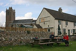
 The village pub and church, Clayhidon | |
| Location | |
| Grid reference: | ST161156 |
| Location: | 50°56’2"N, 3°11’42"W |
| Data | |
| Post town: | Cullompton |
| Postcode: | EX15 |
| Local Government | |
| Council: | Mid Devon |
Clayhidon is a village and parish in the Hemyock Hundred of Devon, in the Blackdown Hills. The northern boundary of the parish also forms the Somerset border.
The parish church is St Andrews.
Outside links
| ("Wikimedia Commons" has material about Clayhidon) |