Chelsham
| Chelsham | |
| Surrey | |
|---|---|
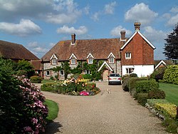
 Beddlestead House, Chelsham | |
| Location | |
| Grid reference: | TQ383593 |
| Location: | 51°18’60"N, 0°-0’60"W |
| Data | |
| Post town: | Warlingham |
| Postcode: | CR6 |
| Dialling code: | 01883 |
| Local Government | |
| Council: | Tandridge |
| Parliamentary constituency: |
East Surrey |
Chelsham is a village in eastern Surrey, in the Tandridge Hundred. It is in the Metropolitan Green Belt, three miles from Oxted and twenty-four miles from the county town, Guildford. Together with Farleigh the total population of the civil parish was 356 as measured by the 2001 census.

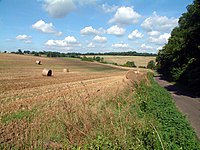
Chelsham stands high in the North Downs and commands views for a long distance, including over London.
History
Flint implements and flakes are not uncommon in Warlingham and Chelsham: evidence of a Neolithic population frequenting the area.[1]
Near Chelsham Court Farm are the foundations and walls of a Romano-British villa.[2][3]
Chelsham appeared in Domesday Book as Celesham held by Robert de Wateville from Richard de Clare, just one of his many local pseudonyms. Its Domesday assets were: 1 church, 11 ploughs, from customary dues 1 hog. It rendered £15.
Three manors existed at times: Chelsham Watevile; Chelsham, also known as Chelsham Court; and Chelsham Le Holt, also known as Rowholt. Mediæval earthworks in Holt Wood[4] and Henley Wood[5] are thought to be associated with these.
Warlingham Common, a large tract of common land was inclosed in 1866 and extended into Chelsham.[1]
A small estate of detached and semi-detached houses now occupy that land that was once the site of Warlingham Park Hospital, built as Croydon Mental Hospital in 1903 on the borders of the north of the parish. It cost £200,000 to lay out grounds and erect the buildings, including the iconic central tower which is the only edifice that still stands.
By 1911 Chelsham Place had become a farmhouse.[1]
Parish Church

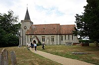
The Church of St Leonard is a 13th-century church largely rebuilt in the 19th century. It was built to serve the farms in Chelsham, and still sits in farmland in the centre of the roads and bridleways of the parish.
About the village
A large triangular village green, bounded by two roads, named Bull Green, is managed by the parish council and hosts annual events.
In parts well wooded, the area is generally somewhat barren and featureless in the nearer landscape. The highest point of the North Downs Area of Outstanding Natural Beauty is a slight, gentle rise, about three miles south of the village along Croydon Road at Botley Hill.
The village is three miles north of Oxted, which sits below the uplands upon which Chelsham stands. While Chelsham seems a remote, countryside village, the deep, urban townscape of Croydon is just six miles to the north.
Outside links
| ("Wikimedia Commons" has material about Chelsham) |
- Chelsham: Exploring Surrey's Past
References
- ↑ 1.0 1.1 1.2 A History of the County of Surrey - Volume 4 pp 270-274: Parishes: Chelsham (Victoria County History)
- ↑ National Heritage List 1019285: Romano-Celtic Villa (Scheduled ancient monument entry)
- ↑ An assessment of a Romano British villasite at Chelsham, Surrey E.M. Davies, 1997, 7 pages paperback with maps and plans, Surrey Archaeological Museum, Castle Arch, Castle Gate, Guildford GU1 3SX
- ↑ National Heritage List 1005935: Earthworks in Holt Wood (Scheduled ancient monument entry)
- ↑ National Heritage List 1005945: Earthworks in Henley Wood (Scheduled ancient monument entry)
