Difference between revisions of "Castlecary"
(Created page with "{{hatnote|Not to be confused with Castle Cary in Somerset}} {{Infobox town |name=Castlecary |county=Dunbartonshire |picture=Castlecary Castle.jpg |picture caption=Cast...") |
|||
| Line 17: | Line 17: | ||
|website= | |website= | ||
}} | }} | ||
| − | '''Castlecary''' is a small village in [[Dunbartonshire]], in the easterm detached part of that shire, close to the border with | + | '''Castlecary''' is a small village in [[Dunbartonshire]], in the easterm detached part of that shire, close to the border with [[Stirlingshire]]. Castlecary is close to the county's large new town: [[Cumbernauld]]. It stands to the west of the A80 road and south of the [[Forth and Clyde Canal]]. |
Like many other villages in the area, Castlecary has Roman heritage. The route of the [[Antonine Wall]] passes close to the village. A Roman camp existed at Castlecary, first constructed around the year AD 80, possibly during the fourth campaign season of governor Gnaeus Julius Agricola. Excavated in 1902, the Roman fort was probably devastated by the 2nd century. | Like many other villages in the area, Castlecary has Roman heritage. The route of the [[Antonine Wall]] passes close to the village. A Roman camp existed at Castlecary, first constructed around the year AD 80, possibly during the fourth campaign season of governor Gnaeus Julius Agricola. Excavated in 1902, the Roman fort was probably devastated by the 2nd century. | ||
Latest revision as of 21:36, 13 July 2015
| Castlecary | |
| Dunbartonshire | |
|---|---|
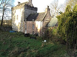
 Castlecary Castle | |
| Location | |
| Grid reference: | NS783779 |
| Location: | 55°58’44"N, 3°56’56"W |
| Data | |
| Post town: | Glasgow |
| Postcode: | G68 |
| Dialling code: | 01324 |
| Local Government | |
| Council: | North Lanarkshire |
| Parliamentary constituency: |
Cumbernauld, Kilsyth and Kirkintilloch East |
Castlecary is a small village in Dunbartonshire, in the easterm detached part of that shire, close to the border with Stirlingshire. Castlecary is close to the county's large new town: Cumbernauld. It stands to the west of the A80 road and south of the Forth and Clyde Canal.
Like many other villages in the area, Castlecary has Roman heritage. The route of the Antonine Wall passes close to the village. A Roman camp existed at Castlecary, first constructed around the year AD 80, possibly during the fourth campaign season of governor Gnaeus Julius Agricola. Excavated in 1902, the Roman fort was probably devastated by the 2nd century.
About the village
There is little in the village today, save for the local Castlecary House Hotel. The nearby Castlecary brickworks in Allandale at one stage provided local employment, but the site is now derelict and awaiting redevelopment. One suggested use of this site has been the construction of a new "park and ride" railway station, to be called 'Allandale'. It had been previously suggested that the station be called Castlecary, but representations were made to the scheme's sponsors not to call it this given the existence of a Castle Cary Station in Somerset and the potential for confusion between the two.
There was nevertheless previously a Castlecary railway station, now long since closed. This was the site of a major rail accident on 10 December 1937, when two trains collided with one another. The accident cost the lives of 35 people, with a further 179 injured.
Castlecary also lends its name to a viaduct which crosses the A80. These are commonly known as the "Castlecary Arches".
Outside links
| ("Wikimedia Commons" has material about Castlecary) |