Car Colston
| Car Colston | |
| Nottinghamshire | |
|---|---|
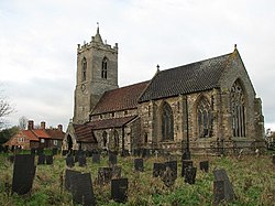
 St Mary's Church, Car Colston | |
| Location | |
| Grid reference: | SK719428 |
| Location: | 52°58’40"N, 0°55’42"W |
| Data | |
| Population: | 185 (2011) |
| Post town: | Nottingham |
| Postcode: | NG13 |
| Local Government | |
| Council: | Rushcliffe |
| Parliamentary constituency: |
Newark |
Car Colston is a village in Nottinghamshire. It is to be found just off the A46 road (the Romans' Fosse Way), three miles north of Bingham and two miles west of East Bridgford. Other nearby villages and hamlets include Little Green, Screveton, Scarrington and Newton.
Most of the present-day buildings in the village date from the 18th and early 19th centuries.
The population of the civil parish at the time of the 2011 census was 185.
Contents
Name
The place appears as Colestone in the Domesday Book of 1086, and as Kyrcoluiston in 1242: variants of the latter appear at occasions after this..[1]
The original affix Kyrc is the Old Norse kirkja or Mercian English circe, meaning 'church'. By the Middle English period, this had become ker. The name 'Colston' seems to contain an Old Norse personal name Kolr, with the Old English tun (a farmstead or village or estate).[2][3]
History
The earliest signs of human occupation date from the Bronze Age. There are remains of the foundations of a Roman villa in the south-west corner of the village.
In the 1086 Domesday Book, "Colestone" is recorded with three manors.
Car Colston was the home of the notable local historian of Nottinghamshire, Robert Thoroton (1623–1678).
The population of Car Colston was 152 in 1801, 213 in 1821, and 249 in 1831.[4]
Parish church
The parish church is named 'St Mary the Virgin'.
The church forms a joint Anglican parish with St Wilfrid's Church, Screveton, and both belong, with Flintham, Kneeton and East Bridgford, to the Fosse Group of Parishes.
There is a Methodist church at Scarrington, a mile and a half away.[5]
About the village
The village pub is the Royal Oak on The Green, which is a feature of the village. There are also shops and other local services in Bingham.
The two conspicuous village greens: the Large Common, of sixteen and a half acres, and the Little Common of five and a half acres. These originated in the Elizabethan era. They are alternatively known as Large Green and Little Green. In 1598 landowners had fields within the parish enclosed, but agreed on leaving the greens open so that cottagers could graze their cattle, geese and horses. Three roads from the village show fence posts put in place to support gates preventing the animals escaping, which have since been removed to allow vehicular access. These rights are still in use and the parish Common Rights Committee continue to enforce them.[6]
Car Colston has a private pre-school at Old Hall Farm.
Sport and leisure
- Cricket: Car Colston Cricket Club, which plays on the village common
The Annual Presidents' Day celebration for the cricket club sees them play local rivals Flintham Cricket Club for the John Gilbert Trophy. Gilbert played for the club all his life until his passing in 2015. On Presidents' Day some 250 people attend a summer luncheon and watch the match from a marquee.
Outside links
| ("Wikimedia Commons" has material about Car Colston) |
References
- ↑ J. Morris, ed., Domesday Book: Nottinghamshire (Chichester, 1977) 1,56; 9,107; 11,24; Book of Fees, 3 vols., 1922-31.
- ↑ Gover, J. E. B.; Mawer, A. & Stenton, F.M.: 'Place-Names of Nottinghamshire , Part' (English Place-Names Society, 1940), page 223
- ↑ Mills, Anthony David: 'A Dictionary of British Place-Names' (Oxford University Press, 2003) ISBN 978-0-19-852758-9
- ↑ White, William: 'History, Gazetteer and Directory of Nottinghamshire...' (1832), p. 479
- ↑ Grantham and Vale of Belvoir Methodist Circuit: Scarrington
- ↑ "Towns and Villages Around Nottingham | Car Colston". http://www.visitoruk.com/Nottingham/car-colston-C592-V30510.html.