Burridge
From Wikishire
Revision as of 22:20, 13 September 2022 by RB (Talk | contribs) (Created page with "{{Infobox town |name=Burridge |county=Hampshire |picture=New housing at Burridge - geograph.org.uk - 2243791.jpg |picture caption=New housing in Burridge |os grid ref=SU521101...")
| Burridge | |
| Hampshire | |
|---|---|
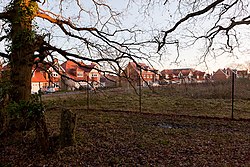
 New housing in Burridge | |
| Location | |
| Grid reference: | SU521101 |
| Location: | 50°53’28"N, 1°15’50"W |
| Data | |
| Post town: | Southampton |
| Postcode: | SO31 |
| Dialling code: | 01489 |
| Local Government | |
| Council: | Fareham |
Burridge is a village in the south-east of Hampshire, on the south side of the tidal River Hamble and attached to neighbouring Swanwick. It has become an outer village in the conglomeration which expands between Southampton to the north-west and Fareham to the south-east.
The village is about 14 miles south of Winchester, on the A3051 between Botley and Park Gate. It is also to the north of Sarisbury and to the west of Whiteley. The village was formerly known as Caiger's Green, but the name 'Burridge' became more popular as the village grew (named after Burridge Farm).
The traditional industry hereabouts was the growing of strawberries, which were distributed by rail from Swanwick railway station.
Sport
- Cricket: Burridge Cricket Club
- Football: Burridge AFC